|
|
|
Global Change and Subsistence Rangelands in Southern Africa: Resource Variability, Access and Use in Relation to Rural Livelihoods and Welfare
TASK 0 PROJECT DOCUMENT
A Preliminary Report and Literature Review for Lesotho
Contributors:
Makoala Marake
Chaba Mokuku
Moeketsi Majoro
None Mokitimi
National University of Lesotho
P O Roma 180
Lesotho
1998
CONTENTS
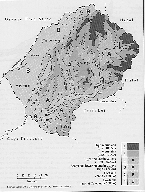
The Physical Description Ecosystems and Species Diversity
The Agricultural Sector in the Lesotho Economy
Annex 1: A Summary of Basic Biophysical Data from Lesotho, collated by the Spanish Team
Source: Schmitz & Rooyani, 1987.
Geology
Geomorphological Unit
Associated Soil Series
Lesotho Formation
Steep & middle slopes
Popa & Matšana
Accumulation glacis
Fusi & Thabana
Planation surface
Machache, Nkau, Sefikeng, Tumo, Matšaba, Seforong, Ralebese, Matela
Alluvial deposits
Phechela, Khabo, Sofonia, Maseru dark
Clarens Formation
Structural plateau
Matela, Berea, Ntsi, Qalaheng, Thoteng, Theko
High structural plateau
Lekhalong, Tšenola, Sani
Burgersdorp, Molteno& Eliot Formations
Accumulation glasis
Maliehe, Bosiu, Majara, Moshoeshoe, Tsiki, Sephula, Tšakholo, Maseru
Planation surface
Leribe, Matela, Qalo, Hololo, Rama
Alluvial deposits; high terrace
Matšaba, Seforong, Ralebese, Kubu, Khabo
Alluvial deposits; middle terrace
Khabo, Kubu, Bela, Phechela, Maseru, Maseru dark
Alluvial deposits; low terrace and flood plain
Caledon, Sofonia, Kolonyama, Phechela
Dolerite dykes & sills
Ralebese
Water Resources
Lesotho’s water resources can be summarised by the general characteristics of precipitation, surface water/stream flow and ground water. These components form major components of the hydrological environment. Taking the water balance into account, the overall water output for Lesotho is 159.53 m3 per second (TAMS, 1996).
Topography influences the precipitation regimes in Lesotho. Rainfall increases with altitude from an average of 450 mm in the SRV to the lowlands along the south east and mountain foothills to more than 1,000 mm in the north eastern parts of the country (Sekoli, 1997). Eighty five percent of the annual precipitation falls between October and April and recedes in May, reaching a minimum during the months of June to August. However, during this period, snowfall is frequent in the highlands and occasionally in the lowlands. This spatial and temporal variability makes Lesotho a drought prone environment.
The country is drained by three major rivers, the Senqu River, Makhaleng River and Mohokare river systems. Runoff characteristics of these catchments reflect the physical character of the systems and affect flow regimes in the short and long term. Rainfall determines flow rates. High flows are normally observed during the rainy seasons and low flow rates in the dry season. Factors such as density and stream distributions, overland and channel slope, catchment storage, soils/geology and land use patterns affect and modify the flow regimes and hydrological output (Tšehlo, 1997).
The occurrence of groundwater is determined by aquifer characteristics in the different parts of the country. Aquifers vary spatially and temporally due to the nature and lithology of the different geological formations particularly local fracture, joint patterns, and topography (TAMS, 1996; Tšehlo, 1997).
Ecosystems and Species Diversity
Past Changes in the Condition of the Environment
Evidence from palynologic, geomorphologic and pedologic studies indicates that there has been Quaternary environmental changes in the Vaal and Orange catchments of the interior (26-28oS) where colder periods with high rainfall alternated with warmer and drier periods (Van Zinderen Bakker and Butzer, 1973). These cycles were associated with changes in biotic communities. For example, drier periods encouraged xeric vegetation during the Holocene while wetter conditions promoted mesic grassland during the Upper Wurm Pleniglacial period. These ecological fluctuations are primarily attributed to natural climatic changes over an extended period of time.
Recent Environmental Changes
Vegetation
There is lack of empirical data to explicitly show the trend of vegetation changes in Lesotho. However, historical records indicate that major vegetation changes have taken place in Lesotho. Accounts of early travellers and evidence of surviving vegetation suggest that has been recent vegetation changes within different ecological zones of Lesotho. The lowlands of Lesotho supported a dense grassland with an open woodland and riverside willow thickets along major rivers. In addition, the scarp slopes and sheltered Kloofs and hollows in the hills supported dense woodlands with species such as Podocarpus latifolius, Cussonia spicate, Euclea ramosa, Ocotea bulleta and Aloe capensis (Germond 1967, Killick 1963, McVean 1977). Valley flats contained tussock grass marshes, reed and Cyperus beds which formed natural water spreading systems over the flood plains ( McVean, 1977). Many marshes, reed and Cyperus beds have disappeared, but places which once supported these wetlands are still referred to as mokhoabong (wetland) and mohlakeng (Reed bed). These vegetation types probably extended to some 2,000 metres above sea level to be succeeded by Montana scrub.
The sub-alpine scrub occurred within the sub-alpine belt at elevations above 2,000 metres above sea level. This vegetation type was dominated by Leucosidea sericea and Buddleia salviifolia, with patches of tall herb meadows in wetter areas and drier grassland on the ridges. The Buddleia-Leucosidea scrub was sometimes continuous with shorter Passerina, Cliffortia, Philippia and Athanasia scrub mainly on northern slopes, which are drier. This vegetation type has apparently been converted into a temperate grassland by fire (Jacot-Guillarmod, 1971; Weiland, 1982).
The alpine belt occurs above the sub-alpine scrub at 2,800 metres above sea level. There have not been any serious changes in vegetation within this zone. The alpine area contained numerous spring bogs, wet herb and sedge meadows. The grassland was dominated by Merxmuellera, Festuca, Pentaschistis and various heaths of Erica and Helichrysum. Heavy grazing by livestock, construction activities and mining have adversely impacted on the spring bogs.
Fauna
Animal diversity in Lesotho has changed due to factors such as habitat loss, direct slaughter and competition from large numbers of domestic stock on the available rangeland. Earlier accounts suggest that large game such as blesbok, zebra, wildebeest, eland and at least five species of antelopes were present in Lesotho (McVean, 1977; Lesenya, 1988). These reports are supported by the observation that many of these species which are extinct in Lesotho are still abundant in neighbouring parts of southern Africa. Another piece of evidence that supports the aforementioned accounts is derived from names of places such as Liphiring (hyenas) in Mohale's Hoek, clans such as Batloung (elephants) and commonly used names such as Tau (lion), which are given to people. All these names suggest that these animals were once present in Lesotho. At present a few species of large mammals remain in very small numbers in the country and these include mountain antelopes such as Grey reebuck (Pelea capreonus), Mountain reebuck (Redunca fulvorufula), Klipspringer (Oreatragus oreatragus) and baboons.
Furthermore, the information available on species of birds in Lesotho indicates that up to 16 species of birds that occurred in the country prior to 1940 could be extinct since there are no recent records of their presence (Osborne and Tigar, 1992). These absent species include species such as Ostrich (Struthio camelus) and African rail (Rallus caerulescens).
Current State of Biodiversity
Ecosystems and Habitats
The diversity of vegetation types is commonly used to express ecosystem diversity since vegetation has an impact on the abundance and distribution of animals. Lesotho is generally considered to be a grassland biome with a limited forest cover (Low and Robello, 1996). The grassland biome is subdivided into six grassland types. Table 2 presents the vegetation types of Lesotho and their corresponding area coverage. The grassland of Lesotho appears to be deteriorating at an alarming rate due to unsustainable range management practices. Presently, approximately 359,680 hectares of rangeland has been invaded by Karoo shrub, Chrysocoma ciliata. This degraded area consists of about 16 percent of the entire rangeland.
Table 2: Vegetation types, area covered and proportion of conserved areas
Compiled from Lowe and Robelo, 1996
Vegetation Type
Synonyms
Area (km2)
Prop. Conserved (%)
Prop. of Country (%)
FOREST BIOME
Afromontane Forest
Montane Forest; Knysna Forest; North-eastern Mountain Sourveld; Highland & Dohne Sourveld
1
0
0
GRASSLAND BIOME
Highveld Grassland Types
Moist Cold Highveld Grassland
Cymbopogon-Themeda Veld Transition; Aristida unciformis-Eragrostis plana Grassland North-eastern Sandy Highveld; Highland Sweet Grassland; Moist Cool Temperate Grassland; Highland Sourveld to Cymbopogon-Themeda Veld Transition
6,689
0
22.63
Moist Cool Highveld Grassland
Cymbopogon-Themeda grassland; Themeda triandra-Eragrostis curvula grassland
198
0
0.67
Wet Cold Highveld Grassland
Rhus dentata-Leucosidea Thicket; High Cold Sourveld
58
3.28
0.2
Mountain Grassland Types
Afro Mountain Grassland
Themeda-Festuca Veld; Monocymbium ceresiiforme-Tristachyar á& leucothrix Grassland
15,489
0
52.4
Alti Mountain Grassland
Merxmuallera-Festuca grassland;Themeda-Festuca Alpine veld; Erica-Helichrysum Heath; Erica-Helichrysum-Eumorphia Sedge Heath
7,118
1.08
24.08
Moist Upland Grassland
Hyparrhenia hirta Tall grassland; Highland Sourveld; Dohne Sourveld
3
55.78
0.01
Total Area
29,558
0.27
100
Environmentally Sensitive Areas
Wetlands
Mires (bogs and fens) are common in the highlands of Lesotho. These wetlands occur where precipitation exceeds potential evapo-transpiration, creating a net surplus of water. Mires are of Holocene period and consist of peaty-loam deposits and are commonly found in riverheads. They tend to purify and regulate the flow of water into streams. Mires are variable in size, ranging from several square metres to several square kilometres. The vegetation is predominantly made up of mat-forming miniature plants.
One conspicuous feature of bogs is the presence of hummocks. It appears that hummocks are a result of the process of succession where shallow pools are occluded by algae and bryophytes. This paves the way for invasion by higher plants leading to development of hummocks (Hughes and Hughes, 1992). High grazing pressure and trampling by livestock increasingly degrades many peat wetlands. Road construction in the mountain areas also contributes to wetland degradation.
Afro-alpine Ecosystem
The climate of the afro-alpine zone differs dramatically from that of other ecological zones and it is a key determinant of the unique alpine communities. The Maluti/Drakensberg alpine region contains unique habitats including bogs and fans. The region also has high levels of endemic plants. There is a total of approximately 1,375 species of plants (30 percent endemic), 250 species of birds, 50 species of mammals and 30 species of amphibians and reptiles.
The afro-alpine area in Lesotho is currently under heavy grazing pressure by domestic livestock. This is particularly evident in bogs, which are rapidly loosing their hydrologic function due overgrazing and trampling during summer months. Species Diversity and Conservation Status
Flora
Lesotho has approximately 2,000 species of flowering plants. Many interesting species occur within the Maloti-Drakensberg mountain range, which is considered to be a regional hot spot. These mountains cover 35,000 km2 with 60 percent located in Lesotho. The number of plant species found within the Maloti-Drakensberg area is estimated at 1,750, of which 30 percent are endemic.
Most endemics occur in heathlands and bogs of the upper alpine belt (Hilliard and Burtt, 1990). Examples of endemic plant taxa in the region inter alia include: Aloe polyphylla (spiral aloe), Aponogeton ranunculiformis (water lily), Kniphofia hirsutas (red-hot poker), Dierama jucundum (Harebell) and Dianthus basuticus.
Fauna
Information on diversity of animals in Lesotho is sparse and, as a result, little is known about occurrence, abundance and distribution. Table 3 below gives some general information regarding animal diversity in Lesotho.
Table 3: Faunal Diversity in Lesotho
Group
Number of Species
Mammals
54
Birds
288
Snakes
16
Frogs and Toads
20
Fish
18
Swallowtail Butterflies
8
Total
404
Conservation Measures
Conservation of species is commonly done through establishment of protected areas in the wild (in situ) and through ex situ preservation which serve as a back-up to in situ conservation. Both forms of conservation are presently underdeveloped in Lesotho.
In Situ Conservation
Conservation of plants and animals is best done in the wild (in situ). Protected areas of different categories can play an important role in conserving Lesotho’s biodiversity. For example, some could be used for long-term ecological studies, while some may be important for sustainable development. At present about 0.7 percent of the total land area in Lesotho is under some form of protection. It is envisaged that the number of protected areas will increase in the near future. Table 4 gives the IUCN (1980) classification of existing and proposed protected areas in Lesotho with their respective management objectives.
Table 4: Protected Areas in Lesotho
IUCN Category
NAME
Management Objective
Category II
- Sehlabathebe Wild Life Sanctuary and National Park
- Masitise Nature Reserve
- Proposed Tšehlanyane Nature Reserve
Managed Primarily for ecosystem protection and recreation
Category III
- Thaba-Bosiu Mountain
- Proposed Liphofung Natural Monument
- NUL Botanical Garden
- Proposed Qoaling National Botanical Garden
- MOA Arboratum
Managed mainly for conservation of specific natural or cultural feature
Category IV
Proposed Management Area
Managed mainly for conservation through management intervention
Category V
Proposed ‘Muela Reserve
Managed mainly for land and seascape conservation and recreation
Category VI
- Maboella Areas
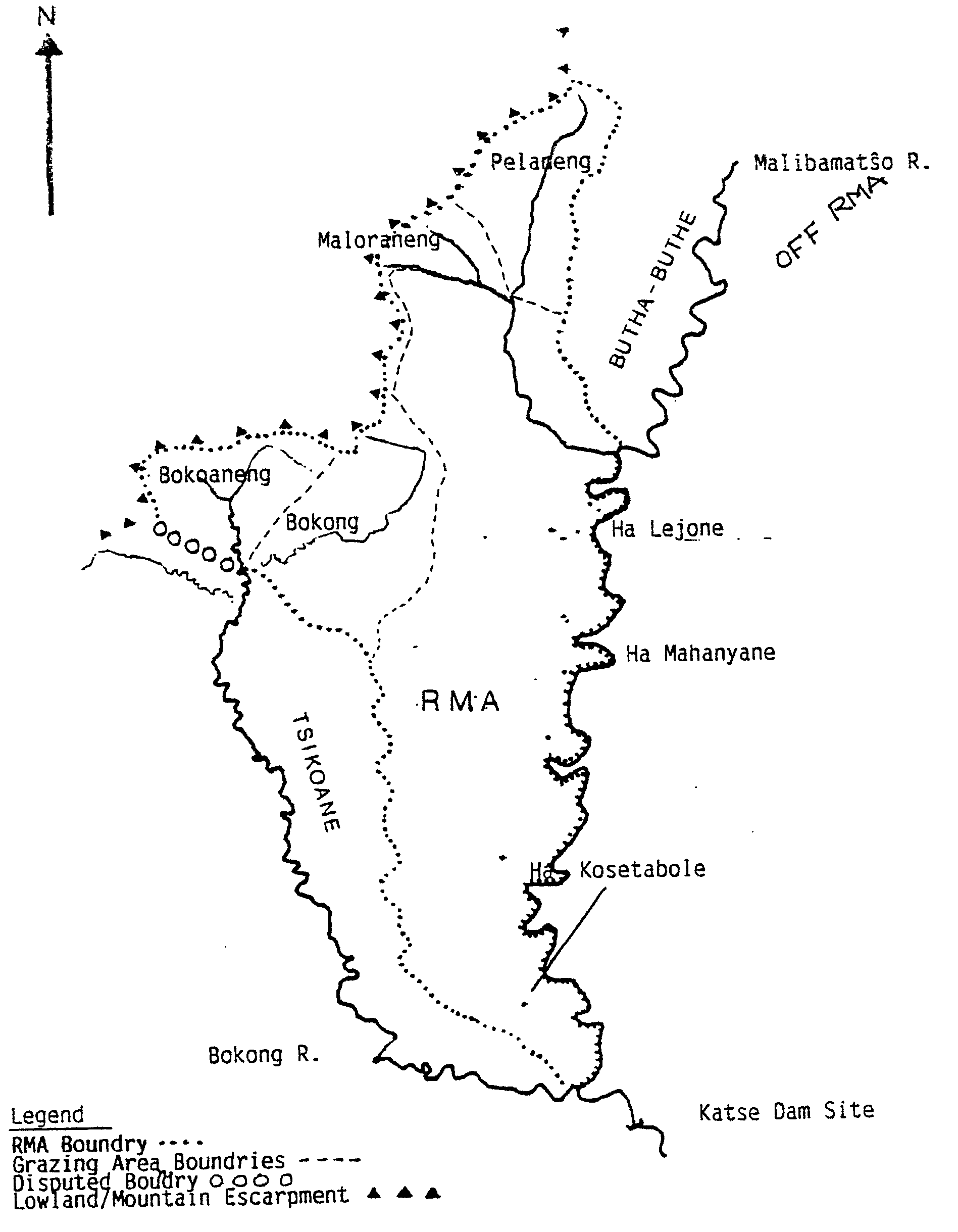
- Sehlabathebe RMA
- Pelaneng/Bokong RMA
- Malibamatšo/Matsoku RMA
- Qhoali RMA
- Proposed Biosphere Reserve
Managed mainly for the sustainable use of natural ecosystems
Gazetted Areas
At present, only two areas, the Sehlabathebe Wildlife Sanctuary and National Park and the Masitise Nature Reserve are protected primarily for ecosystem protection and recreation. These two areas cover approximately 6,495 ha. In addition, three more areas totalling 4,012 ha are currently being developed into biodiversity conservation areas. Gazetted areas in Lesotho cover only 0.35 to 0.7 percent of the total land area.
Sustainable Use Areas
Sustainable use areas encompass those areas which managed primarily for the sustainable use of natural ecosystem, but which indirectly conserve biodiversity.
1) Maboella Areas
The maboella regime is a communal system that governs access to rangeland resources to ensure sustainable use of winter grazing areas, thatching grass, reeds and wood resources. This is an indigenous system, which was developed in the late eighteenth century by the Paramount Chief Moshoeshoe I and administered by local chiefs and headmen. This system is under stress to the point where it has collapsed in some areas due to declining traditional authority and an increase in population, whilst in others the scarcity of resources has actually strengthened the maboella regime.
2) Range Management Areas (RMAs)
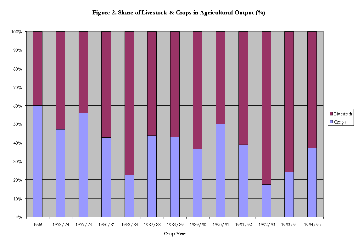
The rangelands of Lesotho are primarily used for livestock grazing. Rangeland degradation has reached a critical level due to overgrazing and poor range management practices. Overgrazing has in turn led to progressive replacement of palatable grasses by invader species such as Chrysocoma ciliata. Annual soil loss from rangelands is estimated at 23.4 million tons per year. Frequent droughts also contribute to range degradation. Range Management Areas (RMAs)/Grazing Associations (GA) are specially designated management units designed to promote sustainable use of Lesotho’s rangelands.
This approach, which was initiated by the Ministry of Agriculture in 1978, is aimed at empowering, training, and advising communities to enable them to control and manage their grasslands. The associations have attracted more than 50 percent of livestock owners. To date, six areas with a total of 185,684 ha have been designated as RMAs. Also, the establishment of five additional RMAs is pending, and another additional one has been proposed. Furthermore, the suitability of an additional area of 5,000 ha, to be managed as an IUCN-Categorised "Sustainable Use Area", is to be investigated. Monitoring of the state and trends of the protected areas have been conducted in two RMAs and further monitoring exercises in other areas will be considered depending on the availability of resources.
3) Forest Reserves
In 1972, the Ministry of Agriculture launched the Lesotho Woodlot Project (LWP) which was to provide farmers with fuelwood and construction materials while at the same time conserving soil and water. The Forestry Division (FD) which was established in 1987 within the Ministry of Agriculture took over the activities of LWP. There are currently 487 existing forest reserves and government-owned plantations in the country.
Ex Situ Conservation
Ex situ conservation, which in Lesotho is the responsibility of the Government through the Ministry of Agriculture and the National Environment Secretariat (NES), is underdeveloped. In addition, some institutions, NGOs, and individuals are currently involved in ex situ conservation by propagating some plant species of economic importance.
Lesotho has one botanical garden managed by the National University of Lesotho (NUL) and one arboretum managed by the ministry of agriculture. The Lesotho Highlands Development Authority (LHDA) is developing a garden at Katse through cultivation of high altitude species, while NES has been allocated a site in Maseru for the establishment of the proposed National Botanical Garden. In addition, the Ministry of Agriculture in Lesotho has embarked on conservation of germplasm as a part of a regional strategy by the Southern African Development Community (SADC) for Conservation and Sustainable Use of Plant Genetic Resources.
Some small-scale ex situ conservation initiatives by individuals include propagation of the endangered endemic, Aloe polyphylla in Maseru and nurseries of medicinal plants in Maseru, Quthing and Leribe districts. Home gardens are also important. Many horticultural crop varieties are conserved by traditional farmers who depend entirely on recycled seed for home consumption.
Legislation
There is presently no comprehensive legislation for conservation of flora in Lesotho. Most conservation Laws in Lesotho focus on improvement of economic or agricultural benefits rather than direct conservation of flora and ecological processes. Only three pieces of legislation directly address biodiversity conservation and these are the Historical Monuments, Relics, Fauna and Flora Act of 1967, National Parks Act of 1975, and Managed Resource Areas Order of 1993. Nevertheless, an umbrella Environmental Bill that has specific provisions for conservation of biological diversity has been completed to provide the legal framework for new environmental institutions.
Monitoring
There is presently no national monitoring framework of biological diversity in Lesotho. The Lesotho Highlands Development Authority (LHDA) is however, engaged in flora and fauna monitoring programs within two of its areas, the Malibamatšo catchment (Phase 1A) and the Mohale catchment (Phase 1B).
Small-scale baseline studies for flora an initiative by the Range Management Division of the Ministry of Agriculture in Pelaneng/Bokong and Malibamatšo/Matsoku Range Management Areas (RMAs). In 1990/91, twelve permanent transects were established in Pelaneng/Bokong RMA and twenty in Malibamatšo/Matsoku RMA. Monitoring in these two RMAs is however not regular due to lack of resources. A similar baseline survey was carried out by Mokuku (1991) in Mafika-Lisiu alpine area where 30 permanent transects were established.
The regional monitoring program that includes Lesotho are the Southern African Birds Atlas Project (SABAP) which collects the distributional data of birds and the Southern African Frog Atlas Project which is preparing a checklist of frog species that occur in the region.
Table 6: Mine Migrant, Deferred Pay Fund, and Migrant Labour Remittances (M million)
Year
Average
Number of
Migrants
Percent
Change
Deferred Pay
Fund
Percent Change
Migrant
labour Remittances
Percent
Change
1989
126,733
-
-
-
956.7
-
1990
125,786
-1
69.4
-
1,106.1
16
1991
122,188
-3
57.0
-18a
1,205.1
9
1992
119,596
-2
53.3
-6
1,299.1
8
1993
116,129
-3
51.6
-3
1,328.7
2
1994
112,722
-3
47.3
-8
1,401.3
5
1995
103,744
-8
52.6
11
1,489.2
6
1996
101,237
-2
52.9
1
1,652.8
11
Mean
SOURCES: Central Bank of Lesotho and Bureau of Statistics (1995). Percentages calculated from given data.
a
The large decrease reflects the agreed decrease in percentage remitted from 60 to 30 percent.Migrant labour remittances provide households with more income options and an increased variety of goods and services. Yirgou (1995) found that households that had at least one mine migrant used paraffin as a source of energy more than households without a mine migrant. The latter households depend more on biomass fuels such as dung, fuelwood, and crop residue. Thus migrant labour incomes are inversely related to degradation pressure on the environment. As these incomes decline, pressure on the environment is expected to rise. From the table, it is clear that total remittances have grown by just under the rate of inflation, implying no real increases in migrant income. Given that the population has been rising at 2.6 percent annually, it is obvious that migrant incomes are reaching a declining number of households. This will no doubt amplify the role of rangelands as a source of rural livelihoods.
The Labour Force and Employment
The World Bank (1995) estimated Lesotho's labour force at about 800,000 in 1993. Of this, only 28 percent or 225,000 held formal wage jobs including some 116,000 estimated to be in the South African mines (the 1990s rate of retrenchment from the mines is estimated at 300 per month and the most pessimistic scenario is that of 100 percent retrenchment by the year 2020). The remaining 72 percent or about 575,000 were employed in agriculture and informal sectors in rural and urban areas. It is generally believed that 22,000 - 25,000 people enter the labour force every year, while the economy has the capacity to generate only 6,000 jobs each year. 'Brain drain' is ravaging the economy with the country reported to rank second after Zimbabwe (which ranks first on a per capita basis) in exports of skilled labour to South Africa in 1996. This problem ensures that the necessary skills for combating the structural unemployment are never available.
Balance of Payments
There appears to be a worsening current account deficit (21 percent of GNP) as shown by the deterioration from a deficit of 561 million in 1991 to 931 million in 1995. An alarming import-to-export ratio of 13:1 is recorded in 1991; however it improves to 6:1 in 1995 probably due to recovery of export manufacturing. Despite the current account deficits the overall account has shown a surplus throughout the period, due to a healthy capital account comprising largely Lesotho Highlands Water Project capital transfers which have averaged 82 percent of the capital account over this period. Foreign financial reserves have remained comfortable allowing no less than ten weeks of merchandise imports in the period.