|
|
|
INTRODUCTION
The integration of economic development with the sustainable management of natural renewable resources is a problem that exercises scientists, planners and politicians in many parts of the world. There are few places where these issues are more acute than the semi-arid rangelands of southern Africa. Social, economic and biological problems, together with fundamental physical constraints, combine to produce intractable problems.
The traditional nomadic and transhumance systems have been largely displaced by more sedentary lifestyles in ranges characterised by very large seasonal and annual climatic variability. The social fabric of the communities and the ‘health’ of the rangelands are challenged by growing populations, changes in traditional and commercial land tenure, a growing international concern for the conservation of biological resources, growing popular social expectations but decreasing work opportunities, especially in mining, and, of course, global climate change.
The current study, based on three sites in Botswana, Lesotho and South Africa (described later), is firmly based on the need for a cross- disciplinary approach, integrating physical, biological, social and economic studies, and the need for issues to be addressed at community and national policy levels. It is unrealistic to expect that solutions can be found to all the complex issues in the initial 3-year span of the project. However, the general objective is to analyse the dynamic relationships between rangeland state and rural livelihoods and to identify, in the context of southern Africa, policy options and interventions that will optimise, sustainably, the welfare of the range communities while maintaining rangeland productivity and ecological diversity and integrity.
Objectives
Activities
The key activities have been divided into workpackages and include:
Expected Outcome
Overall, the project will lead to the modelling of the dynamic
interaction outlined above, to policy recommendations and options,
potential physical interventions and, possibly, financial priorities
designed to improve the sustainability (ecological, economic and social)
of the subsistence rangeland in southern Africa. It will enable regional
assessment and longer-term planning in the region to prepare for and
anticipate potential impacts of global change. It will identify the major
elements in the relationships between rangeland state and rangeland
productivity. Specific opportunities to improve the management of the
rangelands to increase their biophysical sustainability will be identified
as will the contribution of socio-economic development of the specific
communities.
BOTSWANA
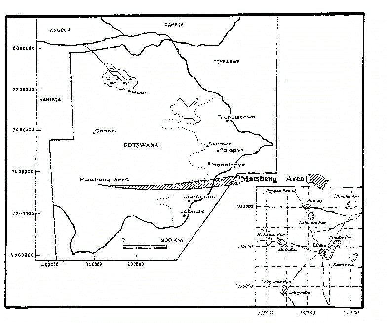
Fieldwork activities are concentrated in the Matsheng villages in southwestern Botswana. Matsheng is the Tswana word for pans, which may hold water during the rainy season. The area is part of the sandveld with low and unreliable rainfall and infertile soils, and where droughts occur frequently. The area is remote, approximately 550 km west of the capital, Gaborone, and is amongst the poorest in the country. It has a population density of less than one person/km2. Gemsbok National Park is to the southwest of the study area. People meet their needs through a combination of livestock, wildlife, crops and veldproducts. In addition, employment elsewhere is of critical importance to the local population.
The following changes in the recent past have had major impacts on the ecology and socio-economic conditions in this area:
The Trans-Kalahari highway, opening up this area to virtually all citizens of Botswana, the Government of Botswana’s 1990 Agricultural Policy and wildlife policies are all likely to have a major impact on the region in future.
Project activities include:
Findings will be fed back to the local communities and to district and central government authorities.
Map of the Matsheng Area, Botswana
LESOTHO
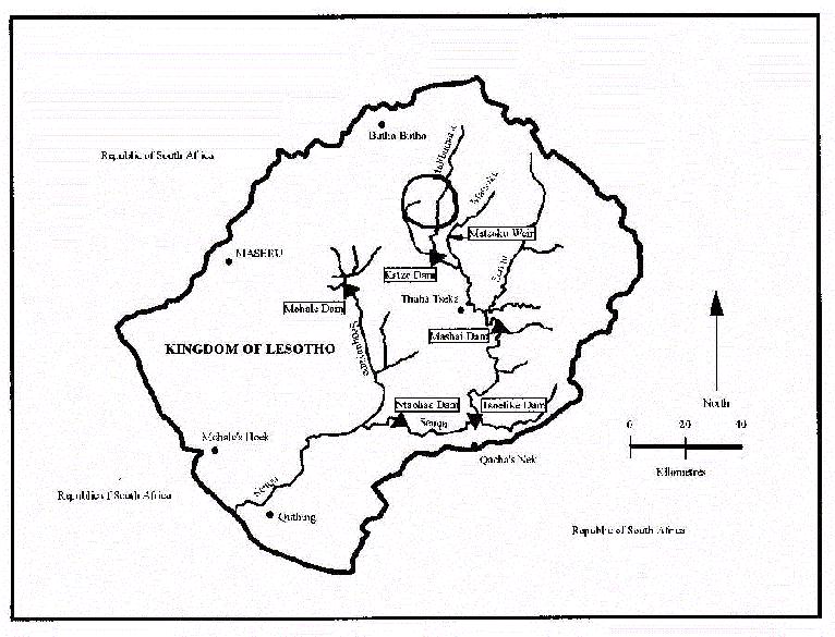
The study area is a mountain rangeland at an altitude ranging from 2,200 to 2,700 metres above sea level. The site is about 160 kilometres northeast of Maseru, the capital. Pressure on the rangeland has increased over time as a result of increasing livestock population, an egalitarian property rights regime, and weak enforcement of grazing guidelines. Overstocking is believed to be a permanent feature of the rangeland. Two management regimes characterise the study area. One falls within the Pelaneng-Bokong Range Management Area (RMA) while the other falls under the traditional cattle post management. The former regime represents a tighter management style and requires increased participation by all members of the Grazing Association in monthly management meetings. The RMA comprises 17 villages with 332 farming households. The inclusion of these two separate, managerially-different areas in the study will allow policy-relevant comparison between the two areas in terms of impact of factors effecting global change as well as responses to such changes.
The Lesotho Highlands Water Project, which has dammed the adjacent Maliba- matšo River, has itself brought about major changes which have biophysical and socio-economic implications. The improved access to the area has resulted in opening the area to more vehicular traffic and tourism.
The project activities include:
A multi-disciplinary research team from the National University of Lesotho is responsible for the study. The University has a current enrolment of about 2,000 students and a teaching and research cadre of about 200 members.
Map of Lesotho Project Area
SOUTH AFRICA
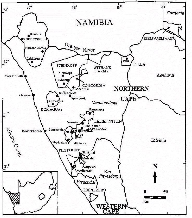
The arid northwestern region of South Africa contains many commercial, privately-owned farms interspersed with a patchwork of communal reserves. The study site, centred around Paulshoek, is one of nine villages in the Leliefontein communal reserve in the Northern Cape Province. Paulshoek is approximately 80 km south of Springbok, the nearest large centre, and about 50 km east of the small market town of Garies. There are 139 households and 800 people in the village comprised largely of old and very young inhabitants. The economically-active citizens send money home to relatives in the village. State-funded child remittance and old-age pensions also contribute significantly to the economy of the village.
Paulshoek falls in the winter rainfall region of South Africa and has a mean annual rainfall of 200 mm and mean annual temperature of 15.9 °C with a large seasonal and daily amplitude in temperature. The vegetation is made up of evergreen shrubs on the uplands, and dwarf succulent shrubs on the lowlands. The major forms of land use in Namaqualand and Leliefontein are small stock farming and a limited amount of cropping. Livestock are herded from about 30 stock posts dispersed throughout the communal area. Overgrazing, losses of plant cover and livestock mortality are common problems, especially adjacent to the village itself.
Some of the major issues impacting on the socio-economic development and ecological integrity of the Leliefontein communal area are:
Project activities in the area are:
Map of South Africa Project Area