|
|
|
INCO-DC Project No. ERBIC18CT970162
Global Change and Subsistence Rangelands in Southern Africa: Resource Variability, Access and Use in Relation to Rural Livelihoods and Welfare
Project Partners:
Centre for Arid Zone Studies, Wales (CAZS)
National Botanical Institute, South Africa (NBI)
National University of Lesotho (NUL)
Norwegian Institute for Nature Research, Norway (NINA)
Pyrenean Institute of Ecology, Spain (IPE)
University of Botswana (UB)
2nd Annual Report
to the European Commission
October, 1999
CAZS, Bangor, Wales
October, 1999
INCO-DC Project No. ERBIC18CT970162
Global Change and Subsistence Rangelands in Southern Africa: Resource Variability, Access and Use in Relation to Rural Livelihoods and Welfare
CONTENTS
Summary
Scientific Annual Report
Management Annual Report
National Botanical Institute, South Africa
National University of Lesotho
Norwegian Institute for Nature Research
Pyrenean Institute of Ecology
University of Botswana
Annex 1: Poster 1 and 2 of Prototype, 3-layered, nested
Model, CORISA(M)
Annex 2: Proceedings of 2nd Joint Workshop held in Paulshoek,
Namaqualand, South Africa, 7th to 12th March 1999 (in 2 separate
volumes accompanying this report to the EC)
Data sheet
Note: Three copies each of publications are being sent to the EC with this report in a separate, accompanying folder. Copies of student dissertations have not been supplied to the EC with this report on the instructions of Mr Dirk Pottier, DG XII.
SUMMARY
Objectives
Activities and Achievements
The key activities are divided into work packages and include:
Project initiation and community participation.
The local teams have carried these out and continue to maintain a dialogue with the communities.
Biophysical data collection and analysis
Many surveys have already been completed but some continue at all sites.
Socio-economic data collection and analysis.
Largely completed at all three sites but, in Botswana and Lesotho, has led to identifying the need for more detailed information on specific issues.
Resource management and policy analysis
This has commenced and will form a major part of the integration processes in Year 3.
Integration and synthesis of data
The Institute of Terrestrial Ecology, Edinburgh, has developed a prototype, 3-layered, nested model, CORISA(M), (Community Rangelands in Southern Africa Model). It is based on a generalised model supported by a series of sub-models for the various components, e.g., household budgets, time allocation, climate, soil, water, plant growth, domestic animals and crops. The framework of the model should allow, fairly readily, the incorporation of elements more relevant to other sites, e.g., the impact of wildlife both for hunting and as a source of finance through tourism or tradeable permits as in the Kalahari. This model was presented as a poster at the GCTE Food and Forestry: Global Change and Global Challenges Conference in Reading, U.K., in September 1999, and as a presentation to a special workshop on "Making Global Change Research Relevant to Pastures and Rangeland Decision-makers", held as part of the GCTE Conference (See Annex 1). A preliminary analysis of some aspects of the potential impact of long-term climate change on the southern African region is also being undertaken.
Expected Outcome
Overall, the project is leading to the modelling of the dynamic interaction outlined above, to policy recommendations and options, potential physical interventions and possibly, financial priorities designed to improve the sustainability (ecological, economic and social) of the subsistence rangelands in southern Africa. It will eventually enable regional assessment and longer-term planning in the region to prepare for and anticipate potential impacts of global change. It is beginning to identify the major elements in the relationships between rangeland state and rangeland productivity. Specific opportunities to improve the management of the rangelands to increase their biophysical sustainability are being identified as is the contribution of socio-economic development of the specific communities.
Problems
The project has not encountered any insurmountable, major setbacks. However, the most disappointing event of the year was the vandalism of the Spanish-donated weather station, the Lesotho team having already been disadvantaged.
SCIENTIFIC ANNUAL REPORT
Introduction
Significant progress has been made in virtually all elements of the project in the last year. The 2nd Project Workshop in March, held in Paulshoek, Namaqualand, allowing members of all the contributing groups (except Dr Christina Skarpe, who was unable to attend) to visit the Paulshoek community, was excellently organised by the NBI team. It provided a vital opportunity to exchange data and experience, engender team spirit, develop the tools for integrating the various components of the work, and begin the iterative process of modelling. As might be expected, specific problems have been experienced in relation to some planned activities. These are described below where they have influenced specific activities. Generally, it must be recorded that the civil unrest in Lesotho in the summer and autumn of 1998 delayed field work in that country. The EC was immediately informed of the difficulty and we thank them for the their understanding response. Other difficulties will be referred to below where they have influenced specific activities.
Execution of Work Plan
Work Package 1. Project initiation and community participation
Task 1a. Study site identification
Task 1b. Survey of community attitudes
Task 1c. Community participation and training
Following site identification and the establishment of working relationships with the three community areas in year 1, dialogue has continued with all three. It has been found that this continuing dialogue is regarded favourably by the communities. It is important to note that work by the NBI group was already in progress in Paulshoek prior to the establishment of this project. Data sets existed on certain elements of the work in the Matsheng villages but there was little integration or village-based participatory work. In Lesotho, on the other hand, while the Lesotho Highlands Water Project has been active in the Pelaneng-Bokong catchment, the NUL has had to start the integrated project essentially from scratch, and seek to secure the trust of the communities.
In all cases, the iteration and report-back has been valued, and aided community interest in the project and further work. Such dialogue has heightened community expectations, especially in Paulshoek but also in the Matsheng villages, of their being early �developmental� outputs. This pressure can only increase in future (see, for example, NBI report, this volume). It is important that some measures are taken to address these hopes without compromising the basic research. However, the dialogue with the community did not prevent the vandalism of the climate station on the RMA in Lesotho, a matter which is dealt with later in this report.
Work package 2. Biophysical data collection and analysis
Task a. Basic survey of water sources and hydrology
Task b. Survey of soil fertility and erodibility
Task c. Ecological analysis
Task d. Estimates of biomass productivity
Task e. Develop a mechanistic understanding of rangeland composition and productivity
Task f. Assess the availability of other rangeland products
Task g. Basic climatic data
At all three sites, with the active support of NINA in Botswana and IPE in Lesotho, work on the individual tasks has proceeded. The rate of progress has varied in relation to the capacity of the teams to handle the individual tasks and to the resources and funding available to the country groups. Details are presented in the individual reports but it should be noted that Botswana have experienced problems in carrying out soil and water analyses, and that Lesotho have had difficulties in securing the ecological skills, with the withdrawal of one of the team. As reported in the NUL report in this volume, it is hoped that alternative sources of expertise have now been identified and activated. It must be emphasised that, as a result of the final EU financial settlement, significant field work was not expected in Lesotho but the group were very keen to be participate in all aspects of the project, and extra funding was secured to allow this to occur although at a lower intensity than in South Africa and Botswana. The biophysical database available in relation to all these tasks in Paulshoek is now sufficient to drive the dynamic model but it is expected that the modelling may itself identify some gaps. The situation in Botswana is following on rapidly.
As explained in the NUL report, this volume, Task g can not be pursued due the vandalism of the weather station, generously donated by the Spanish team. The best approximation will be produced based on "all South Africa" data sets available from the University of Natal. The IPE team have used existing data to produce a detailed examination of a range of biophysical GIS- style maps for Lesotho but at a relatively coarse scale.
Work package 3. Socio-economic data collection and analysis
Task a. Characterise the social structures of the communities
Task b. Characterise the land tenure and water access regimes
As noted in all three country reports, significant progress has been made in completing these tasks. However, in both Botswana and Lesotho this has led to identifying the need for more detailed information on specific issues.
Task c. Characterise the structure of the agropastoral system
Following an advisory visit by Dr Ian Robinson of CAZS, detailed stock recording has commenced. In Paulshoek this has been facilitated by the hiring a young man from the village to ensure that records are kept. A similar initiative in Botswana, using a UB graduate with excellent local connections, has been partly frustrated by his seeking other employment but is continuing with other support.
Task d. Determine the source of rural livelihoods
Task e. Assess the impact of rangeland state and variability on rural livelihoods
See above tasks a-b.
Work package 4. Resource management and policy analysis
Task a. Determine the influence of different landuse practices on rangeland resources
Task b. Determine the influence of policy and institutions on rangeland resources
Task c. Determine the impact of government intervention
These tasks have been initiated in all three countries and will be the focus of much effort in Year 3. The experience of the Botswana and Lesotho teams and their contacts with central government in relatively small countries gives them an advantage in this work compared with the NBI team.
Task d. Develop long-term data sets relating to landuse/land cover change and population growth
While all the groups are seeking to secure all available data, the situation in Namaqualand is greatly strengthened by Dr Coleen Vogel at the University of Witwatersrand, who has a PhD student working specifically on this task. Unfortunately, funding was not available for a similar staff commitment for the other two sites. (See also Work Package 5, Task b).
Work package 5. Integration and synthesis
Task a. Generate process-based models
The whole approach and rationale of this project was based on the insights and recommendations of the Workshop, "Southern African Rangelands Today and Tomorrow: Social Institutions for an Ecologically Sustainable Future", held in Gaborone in 1996, funded principally by START with international support from GCTE and the European Union (including UNITWIN), and the interactive but static conceptual model(s) developed there and reproduced in the Technical Annex to our INCO-DC Project No. ERBIC18CT970162; see also our web site; www.cazs.bangor.ac.uk./rangeland
Joint discussions at the Workshop led to the initial model being adapted in the light of experience and the rectifying of obvious omissions. As the process of data accumulation was furthest advanced in Paulshoek (for the reasons note above), our colleagues at ITE, Edinburgh, have used these data sets to build the integrated biophysical/socio-economic model. Both Drs Andrew Friend and Deena Mobbs attended the Workshop but Dr Friend has since taken a post with NASA in New York. The development of the model is now in the hands of Dr Mobbs although Dr Friend continues to contribute from his new post. A prototype model, named CORISA(M) (Community Rangelands in Southern Africa Model) has been developed. It is based on a generalised model supported by a series of sub-models for the various components, e.g., household budgets, time allocation, climate, soil, water, plant growth, domestic animals and crops. This model was presented as a poster at the GCTE Food and Forestry: Global Change and Global Challenges Conference in Reading, U.K., in September 1999, and as a presentation to a special workshop on "Making Global Change Research Relevant to Pastures and Rangeland Decision-makers", held as part of the GCTE Conference. A copy of the poster is annexed together with a second poster prepared (See Annex 1) as they describe the evolving model in some detail, and a joint paper will be produced by the workshop participants for "Global Change Research".
The framework of the model should allow, fairly readily, the incorporation of elements more relevant to the other sites, e.g., the impact of wildlife both for hunting and as a source of finance through tourism or tradeable permits as in the Kalahari.
Task b. Develop long-term data sets relating to climate change
Progress on this task is similar to that of Work package 4, Task d. Interaction between the southern African partners has been restricted by lack of funds, with partners relying on e-mail communication and workshop attendance for exchange of methodology and data.
Task c. Develop global change scenarios and assess their implications
This task will lead on from the modelling exercise, which has been initiated during this project year.
Task d. Identify development opportunities and interventions
The South African team in particular has initiated several development projects in parallel to this project (see NBI report, this volume). The Centre for Arid Zone Studies is involved in identifying possible sources of drought resistant cereal seeds and the possibility of introducing technical modifications to cultivation practices, e.g., seed priming and transplanting, which are being successfully tested by CAZS in Zimbabwe and elsewhere. These might be especially useful at the Botswana site. The stock-recording methodology developed by Dr Ian Robinson of CAZS is likely to be a useful tool, which will continue to be used by the participating villagers in the future.
Task e. Community feedback
All the teams take great care in the participatory aspects of this project and have regular meetings with representatives of the participating settlements/villages. The field visit by the delegates was an important part of the workshop in Namaqualand, and a member of the Paulshoek community made a valuable contribution as a participant at the workshop. The rationale of this project is closely linked to the view that the main contribution of experts is not to dictate but to explain and reveal the expanse and richness of the natural resource base and facilitate its optimum use at the grassroots, bearing in mind at all times that the final decisions must rest with the local community.
Work package 6. Project coordination and reporting
Task a.
The co-ordination of the project has more or less run smoothly and the details are provided elsewhere in this report. The coordinators have visited the southern African partners on a six-monthly basis throughout and have held reciprocal meetings with project leaders from Spain, Lesotho and South Africa in Bangor. The local coordinators have provided information necessary for reports to be produced on time. The special relationships based on skills and interest between Wales and South Africa, Norway and Botswana, Spain and Lesotho are continuing to develop.
It may be noted that a Botswana team member has commenced her PhD studies at the University of East Anglia, funded from an alternative source. Her field work will be directly related to this project.
Task b.
All the partners are in regular contact with the coordinators in Bangor and, if necessary, with each other. The project team's approach to uniformity of data gathering and data quality was laid out in the First Project Workshop in Gaborone and results compared and modified during the Second Project Workshop in Namaqualand. The Botswana team has provided valuable input into the co-ordination of the project deliverables.
Achievement of Milestones and Deliverables
Progress on Year 1 Milestones
All the above milestones achieved at all sites, but continual reinforcement essential.
Progress on Year 2 Milestones
socio-economic survey completed
rangeland use survey
analysis of relationship of rangeland site and productivity initiated
modelling work initiated
analysis of herd/flock structure, etc, and off take
Deliverables
The following deliverables were listed in the Technical Annex:
1. A series of Research Bulletins will be produced including:
2. The above will be used to produce at least 3 publications in 3 refereed journals, and material for dissemination at relevant international conferences.
The project has produced numerous publications in the form of papers in refereed and non-refereed journals, book chapters, MSc theses, occasional papers and conference posters (see p.12 for complete list). All partners look for opportunities to publicise the work in the popular arena, e.g., the South African team have contributed to the production of a video, and the Botswana team have used the findings of their research in discussions on a Radio Botswana programme.
3. A World Wide Web site will be produced and the documents made available on the site.
The Community Rangelands web site has been up and running since the beginning of the project. All the reports and workshop proceedings to date can be found at this site. It can be located at http://www.cazs.bangor.ac.uk/rangeland/
Fine Tuning of Deliverables
The team is on course to accomplish our milestones and deliverables but it is essential that an interdisciplinary, participatory group should evolve together. We are working according to the Technical Annex but are also aware that it is not desirable to predict the outcome at the outset. To this end we have been discussing the best way of analysing and integrating the data collected from surveys and physical fieldwork to enhance the deliverables which are listed in the original Technical Annex. The Botswana team in particular had major concerns regarding the integration of findings. They felt that a team of their size could end up with many publications on interesting details of rangelands but that they might not be well integrated, leaving many gaps. This would be mirrored on the regional scale, hampering regional comparisons and modelling. The Botswana team took a lead in focusing the minds of all partners on the eventual integration and multidisciplinary nature of the project to avoid such problems.
The project�s priority is on integration of biophysical and socio-economic work by resolving two questions illustrated in Project Figure 1:
Project Figure 1

Under the guidance of the Botswana team, five main blocks of analysis/publication as a possible means of achieving this integration have been devised:
1. STATE OF THE RANGELANDS with the following sub-sections:
| i | State of the rangelands |
| ii | Perceived state of the rangelands |
| iii | Determinants of the state of the rangelands |
| iv | Trends in the state of rangelands in time and in space |
2. RANGELAND PRODUCTS AND PRODUCTIVITY
| i | Supply of products and their regeneration |
| ii | Demand for and use of rangelands products |
| iii | (Over-)utilisation-regeneration |
| iv | Actual and potential use and productivity |
3. RURAL LIVELIHOODS
| i | Sources of livelihood (rangelands: gathering, wildlife and livestock, crops and non-agriculture) and relative importance by stratum (gender, income, ethnicity, location and education) |
| ii | Trends/changes in sources of livelihoods |
| iii | Resource allocation, threshold and returns by activity |
4. RESOURCE ACCESS AND USE
| i | State of resource access: land, water, wildlife and distance to resources |
| ii | Trends in resource access |
| iii | Impact of government policies on resource access |
| iv | Resource use practices and impacts on the state of rangelands. |
5. INTEGRATION OF FINDINGS
In each block/report, we have to make sure that as many arrows interconnecting the constituent parts of Project Figures 1 & 2 are addressed and that, where applicable, new ones are being added.
Project Figure 2

This approach is a challenge in coordinating terms but will be beneficial in the long term as the modelling component becomes more important.
Problems
The project has not encountered any insurmountable set-backs. However, the most disappointing event of the year was the vandalising of the Spanish-donated weather station in Lesotho. The Lesotho team was already disadvantaged from the initial cuts in the budget, which affected them more severely than the other teams. Nevertheless, they had shown great determination by obtaining funds, with assistance from CAZS, from the British High Commission and from their own institution. They had also weathered the political unrest of September last year and invested time and energy, along with the Spanish team, in installing the weather station in a remote area. Despite placing guards at the site, the solar panels and other items were stolen, rendering it unusable. A further problem arose due to the resignation of the Ecologist. However, both these elements were not part of the EC contract in Lesotho but were being funded by additional money from Spain and the U.K. respectively.
The unforeseen claw-back of the advance funds which was not included in the contract came as some surprise and has caused confusion amongst the overseas partners. This claw-back had obviously not been budgeted for. However, it is hoped that through the good offices of the University of Wales, Bangor, the effects of this will be buffered.
Electronic conferencing, which is desired by all partners has not taken off as well as expected for various reasons. Access to the internet and slowness of the system in the non-European countries is partly the cause of this. Telephone lines can be unreliable and some partners have to visit their offices out of hours to avoid the log-jam. We are still hopeful that in the third year, when the modelling component takes off, individuals will succeed in joining the dialogue.
Limited access/slow access to the internet is a constraint on other areas as well. We are encouraging partners to download ProTool, the EC project submission package, so that they can electronically fill in their application forms for grants for continuation of funding. However, this can take many hours, days even, if telephone lines crash during the process.
Publications and Papers
Wyn Jones RG, Young EM, Hoffman MT, Magole L, Petersen A, Arntzen J, Majoro M. 1998. Global Change and Subsistence Rangelands in Southern Africa, an Outline of a European Union Funded Project. Presentation at Conference on "Policy-making for the Sustainable Use of Southern African Communal Rangelands", Fort Hare, 6-9 July, 1998.
Todd SW, Seymour C, Joubert DF, Hoffman MT. 1998. Communal Rangelands and Biodiversity: Insights from Paulshoek, Namaqualand. Proceedings of Conference, "Policy-making for the Sustainable Use of Southern African Communal Rangelands", Fort Hare, 6-9 July, 1998.
*Todd SW, Hoffman MT. 1998. Fenced in and nowhere to go: the story of Namaqualand's communal rangelands. Veld & Flora, September 1998, 84-85.
*Todd SW, Hoffman MT. 1998. Communal Rangelands in Semi-arid South Africa. Veld & Flora, September 1998, p. 82.
*Rohde R, Hoffman MT, Cousins B. 1999. Experimenting with the commons: a comparative history of the effects of land policy on pastoralism in two former 'reserves' in Namibia and South Africa. Occasional Paper Series, Land Reform and Agrarian Change in Southern Africa, Programme for Land and Agrarian Studies, School of Government, University of the Western Cape.
Winter W. 1997. The effects of communal farming on bird biodiversity in a semi-arid environment, Namaqualand, South Africa. Dissertation, University of Cape Town.
Goldberg K. 1998. Investigating the sustainability of medicinal plants and the loss of traditional knowledge in a rural community in Namaqualand. BSc Dissertation, Botany Department, University of Cape Town.
Seymour, C. 1998. Different grazing intensities in arid rangelands: effects on invertebrates on a communal farm in the succulent Karoo, South Africa. MSc Dissertation, University of Cape Town.
Moinde, NN. 1998. The effects of Galenia africana on dominant perennial plant species in Namaqualand, South Africa. MSc Dissertation, University of Cape Town.
Joubert, DF. 1998. Small mammal and bird community structure in commercial and communal rangelands in a semi-arid shrubland in Namaqualand, South Africa. MSc Dissertation, University of Cape Town.
Brundin J, Karlsson, P. 1999. Browse and browsers in south-western Kalahari. Swedish University of Agricultural Sciences. MFS Report 73.
*Arntzen JW. 1998. Rangelands and subsistence livelihoods in southern Africa. LUCC Newsletter, 4.
*Chanda R. 1999. The Role of Attitudes and Behaviour in Environmental Management: Theory and Illustrations from Southern Africa. Poster presentation at the international IHDP Global Change Conference, Japan, 24-26 June 1999.
*Arntzen J, Chanda R, Fidzani N H and Magole L. 1999. Subsistence Livelihoods and Rangeland Dynamics in the Matsheng Area, Kgalagadi North, Botswana. 18 pages. In: Ringrose S, Chanda R. eds. Towards Sustainable Management in the Kalahari Region, 189-209, UB-DRD Conference Proceedings.
Moganane BG, Maembolwa J, Totolo O, Molapong KF. 1999. Changes in soil characteristics along the Kalahari transect in Botswana. In: Ringrose, Chanda R. eds. ibid., 66-73.
Setshogo M, Totolo O, Tacheba G, Skarpe C. 1999. The Biophysical Dimensions of Subsistence Rangelands in the Matsheng Area. In: Ringrose, Chanda R. eds. ibid, 177-187.
*Chanda R, Magole L. 1999. Traditional Questionnaire Survey versus Participatory Rural Appraisal: Complementary or Supplementary? A Comparative Assessment using a Case Study from Botswana. In: Rwomire A. Social science research in Africa. Gaborone: Department of Environmental Science, University of Botswana.
Magole L. 1999. Report of the PRA Workshops in Tshane and Ngwatle. 23 pp.
Chanda R. 1999. Project presentation at seminar series for the School of International Training (for visiting US students), Gaborone.
Chanda R, Moleele N. 1999. Project presentation at the international SAFARI 2000 Conference, July 1999, Gaborone.
Kgabung B. 1999. The impact of livestock encroachment on wildlife and veldproducts availability and utilisation. MSc dissertation, Department of Environmental Science, University of Botswana.
Project mentioned in round-table discussion about water scarcity (Radio Botswana).
A total of 14 papers and posters have been presented by NBI project participants at 6 conferences since the start of the project.
Poster presentation by Prof Gareth Wyn Jones of CAZS and Dr Deena Mobbs of ITE at the GCTE Food and Forestry: Global Change and Global Challenges Conference in Reading, U.K., in September 1999, and a presentation to a special workshop on "Making Global Change Research Relevant to Pastures and Rangeland Decision-makers", held as part of the GCTE Conference.
*Note: Three copies each of publications marked with an asterisk are being sent to the EC with this report. Copies of student dissertations have not been supplied to the EC with this report on the instructions of Mr Dirk Pottier, DG XII.
Outline plans for next year
The individual plans for each country can be found at the end of each country report. This includes inputs from the European partners. Coordinating visits will take place in March and September 2000. A proposal for Accompanying Measures funding is being sought for an international workshop to be held in Maseru, Lesotho, in November 2000.
Prof R G Wyn Jones/Dr E M Young
MANAGEMENT ANNUAL REPORT
Organisation of the collaboration
Collaboration and project management is organised with the Centre for Arid Zone Studies at the hub. Communication is carried out by e-mail, fax, post and telephone, accompanied by annual workshops and 6-monthly visits to the southern African partners by a member of the CAZS management team. The following activities illustrate the degree of cooperation and interaction between partners:
Dr A G Chamberlain visited the southern African partners in November 1998 on behalf of the coordinators. He was briefed on progress being made on project activities and on any problems foreseen in implementing future plans, especially those that might be overcome with assistance from the project coordinators at CAZS.
Dr Juan Pablo Martinez Rica visited CAZS for discussions with Professor Wyn Jones and Dr Young, and Dr Young and Dr Martinez Rica visited ITE, Edinburgh, for a joint meeting with Dr Andrew Friend and Dr Deena Mobbs to discuss the modelling aspects of the project.
Dr Ian Robinson of CAZS visited Botswana and Lesotho in February 1999 to follow up the methodology introduced for self-recording schemes to characterise agropastoral systems extant at the selected project sites. The South African team has been able to progress satisfactorily with the help of a local data collector. Progress in Botswana is being comparatively held back following the departure of their Research Assistant (see individual country report).
Professor Gareth Wyn Jones and Dr Einir Young visited Botswana in March 1999 and travelled to the Tshane and Ngwatle field sites with Ezekiel Chimbombi, the UB Research Assistant, who has since left (see report on University of Botswana). Professor Wyn Jones later travelled to Lesotho for discussions with the Lesotho team and with the British High Commissioner. The former Commissioner, Mr Peter Smith, had allocated money for the project, and the new Commissioner, Ms Kaye Oliver, has also indicated her support.
Dr Timm Hoffman and Dr Rick Rohde visited ITE, Edinburgh, in July 1999 for a detailed exchange regarding modelling. Dr Hoffman also visited CAZS for meetings with Prof Wyn Jones and Dr Young. Dr Deena Mobbs visited CAZS in July 1999 to discuss the progress of the model to date and to prepare abstracts for the IGBP meeting in Reading in September 1999.
Dr Young visited the Botswana and Lesotho teams during September 1999.
Dr Moeketsi Majoro, the Lesotho Project Leader, visited CAZS in September 1999 for discussions.
CAZS is coordinating a submission to the EC for Accompanying Measures funding for an International Workshop to be held in Maseru in November 2000. All partners are being encouraged to use the EC proposal package, "ProTool", and have been receiving e-mail support from Ms Pemberton.
Meetings
The Second Joint Workshop was organised by the South Africa team and held in Paulshoek, Namaqualand. It was attended by members of all participating groups except NINA. The southern African country teams briefed the workshop participants of progress to date. A work programme for the remainder of the project has been agreed, which includes the production by Dr Deena Mobbs of ITE of a model, based on Paulshoek data in the first instance. The workshop was an encouraging exercise in team building and collaboration, and the budgetary restrictions, which prevent more frequent meetings, are regretted by all partners.
Professor Wyn Jones and Dr Deena Mobbs delivered a presentation and a poster on behalf of the project team at the GCTE Focus 3 Conference in Reading, U.K., 20-23 September, 1999.
CAZS produced reports and workshop proceedings and circulated these to all partners and associates. These reports are also posted on the project web site at www.cazs.bangor.ac.uk/rangeland
Exchanges
The exchanges (training periods/stays of more than three months in other laboratories) envisaged in the original proposal were not included in the revised Technical Annex due to budget restrictions imposed by the EU.
Problems
The project is progressing well, with minimum problems. However, the following points have emerged:
First Class
In theory this is a useful tool for inter and intra-group communication, which facilitates direct communication between individual members of each team rather than between coordinators and country leaders. It is not critical, as an effective communication system exists with conventional e-mail but it would enhance the opportunity for a more open dialogue, and provide an extra dimension to discussions at the modelling stage. There is enthusiasm amongst the group but enabling everyone to be connected continues to be challenging.
The main problem identified generally by the EC-funded REM (Reseau d'Enseignment Multimedia) project, with which we are linked, is with network administrators and Internet service providers who are reluctant to cooperate in setting up the system. The Bangor server provider relies on them to allow First Class through their security systems. Within organisations, which have their own computer set-up, there can be problems if the system has firewalls and proxy servers. In theory they are there to make the system work more smoothly but often technicians are not driven by the same sense of urgency. Dr Mobbs, for example, was able to successfully negotiate breaking through the firewall at ITE, Edinburgh, without any bureaucratic obstruction. However, when other, less co-operative network administrators refuse, there is not much that can be done.
We are also relying on partners being able to download material from the Internet. In Africa, this process can be excruciatingly slow and laborious. Additionally, Internet access time in developing countries is often expensive. All our partners are attempting to familiarise themselves with ProTool, and the downloading times have been a nightmare, especially the downloading of Java. It now appears that DG XIII are promoting another management tool, which, in our opinion, will compound the difficulties already experienced.
Finance
The main problem identified during the year has been associated with the claw-back of the initial advance from the payment of the first year's cost statements.
This claw-back condition is not written in the conditions of contract. While this has not caused a problem for the EU partners, developing country partners in southern Africa have in some cases been badly affected as they had, not surprisingly, included within their budgets the funds that were going to be clawed back. Where the work of these partners has been slow in getting off the ground in the first year, low first-year cost statements reflected this. The effect of the advance claw-back has had a more pronounced effect in this case. Sorting out this problem has taken up much of the project coordination team's time, and it is possible that UWB will have to become a banker to these partners to enable them to overcome their financial difficulties in relation to the project.
Continuity of funding after the end of 40 months
It was intended at the outset that this project would represent the beginning of a longer-term project. As we enter the final stages, the source of the next tranche of funding is not immediately apparent. The project is outside the remit of the current round of calls for Framework V. However, if the partnership and momentum are to be maintained it will be essential to maintain financial continuity.
Dr E M Young
NATIONAL BOTANICAL INSTITUTE
Executive Summary
The focus for the year has been on the continuation of the ecological studies and land use production measures in Paulshoek while starting the socio-economic analysis of households in the village. The year has been very active from a research perspective with many different projects initiated and others consolidated. An extensive data set has emerged and a start has been made with the synthesis of the data in process-based models. A comprehensive set of GIS maps have been produced in ARCVIEW. Several peer-reviewed research publications have arisen from this project and the information has been disseminated in many different forums. The Paulshoek group also hosted a successful 2nd Workshop of the project participants in March 1999. Additional funding, used by the Paulshoek community for conservation-related works, has been secured.
Introduction
The project began in October 1997 and this forms the second of our annual reports. The main activities during the course of the year have been to continue with the ecological investigations, to start the socio-economic analysis and to start synthesizing the information via process-based models. All of these objectives have been achieved and the project is well-placed to begin writing up the work in the final year of funding. Most importantly, additional funding from other sources has been secured to enable the community to carry out several conservation-related projects. Details of our activities and some data arising from our work are discussed below.
Milestones
Work package 1. Project initiation and community participation
Task a. Study site identification. Completed.
Task b. Survey of community attitudes. Completed but forms part of ongoing community liaison work.
Task c. Community participation and training. Completed and continuing.
Work package 2. Biophysical data collection and analysis
Task a. Basic survey of water sources and hydrological features.
A first draft of a hydrological study has been completed. The 10 boreholes in the area have been located. Four of these are monitored on a monthly basis by a private consultancy. The data derived from the monitoring programme have been incorporated into the report. The remaining 43 dug wells, fountains and dams have been located, and winter readings (June 1999) for pH and salinity levels have been undertaken at all sites. The location of water sources have been mapped in ARCVIEWä and placed on our Paulshoek GIS database.
Task b. Survey of soil fertility and erodibility.
Earlier research on soil nutrients and mycorrhizas indicated that there were changes in both quantity and spatial distribution of soil traits when succulent karoo vegetation is heavily grazed. We examined the spatial arrangement of soil nutrients in relation to the vegetation at three sites along the fence dividing heavily-grazed rangeland from lightly-grazed rangeland. Analysis of soils is still ongoing but initial results indicate that spatial heterogeneity is reduced under heavy grazing. Preliminary analysis indicates that soil organic matter and nitrogen are lower in surface soils subjected to heavy grazing whilst cations and pH are higher. Results will be subjected to geostatistical analysis, and spatial patterning in relation to vegetation will be examined using GIS.
Task c. Ecological analysis.
The vegetation map is progressing well. Ashia Petersen has completed 90 of the envisaged 150, 10 x 5 m plots that will make up the data for developing the vegetation map. Ms Petersen has identified the plants occurring in the plots and has calculated several statistics concerned with ecosystem function.
Task d. Estimates of biomass productivity.
This work has begun with an analysis of biomass productivity in several key shrub species. Replicates of each species have been marked and biomass estimates made. Harvesting of marked individuals will take place in March 2000. Dr Tony Palmer has also assisted in the analysis of two satellite images. One image was taken in 1972 and the second in 1995. These will be used to assist in developing biomass estimates. Arable land production statistics have also been kept since 1995. The region has experienced a severe drought in the last two years. Few individuals have grown crops this year.
Table 1: The number of farmers who planted crops in Paulshoek, and the key production statistics: 1996-1998.
Variable
Year
1996
1997
1998
No. of farmers
11
10
7
Kg sown
810
1,210
560
Kg produced
11,100
755
0
Ratio of kg sown:produced
13.7
0.6
0
Annual rainfall (mm)
376
162
65
Task e. Develop a mechanistic understanding of rangeland composition and productivity.
This remains a central focus of the study. Work from previously reported studies have now been written up, and 5 papers arising from this work have been accepted for publication in peer-review journals. New studies have been initiated as well which will look at the impact of grazing on flower and fruit production in key succulent species. A phenology study has also been initiated. This will determine the growth, flowering and seed dispersal patterns of about 100 species in the areas. Ongoing pitfall trapping studies are also being conducted to assess the impact of grazing on the invertebrate fauna.
Task f. Assess the availability of other rangeland products.
A study on the use of firewood for energy is nearing completion. Initial data suggest that each household consumes 2.18 tonnes of wood per year per household. This costs each household about R242.37 per month in actual costs plus labour costs. The impact of fuelwood harvesting on re-growth and seedling recruitment has also been determined. As long as the stump of key firewood species is not removed, shrub survival appears not to be affected. The removal of dead shrubs for firewood use has a negative impact on seedling recruitment. In another study the impact of medicinal plant use on the natural resource has been determined. This study concludes that the harvesting of medicinal plants has a minor impact on the resource as it is not carried out to any great extent. Grazing is far more detrimental for some medicinal plants although some weedy species used for medicinal purposes respond favourably to grazing disturbances.
Task g. Basic climatic data.
An automatic weather station was established in Paulshoek in May 1999. Solar radiation, relative humidity, temperature, wind direction, wind speed and rainfall are measured on an hourly basis. The memory module is changed every month by the South African Project Coordinator during his monthly visit to the site. In addition, 12 standard rain gauges have been established throughout the 20,000 ha region. Daily rainfall data are recorded by farmers and collated by a member of the Paulshoek community who is employed on the project. A third station is operational in Paulshoek village itself. Minimum and maximum temperature data, relative humidity and rainfall are recorded at this station. The data indicate that the period since last reporting has been exceptionally dry. This is reflected in the number of stock that have died as a result of the drought.
Work package 3. Socio-economic data collection and analysis
Much effort has been placed on this aspect of the project during the period of reporting. It therefore is reported in a more expanded form than the biophysical data.
Task a. Characterise the social structure of the communities.
In terms of "racial" classification, ethnic identity and language, the people of Paulshoek are a homogenous group. The origin of the population is primarily derived from Namaqualand and the Northern Cape although minor differences are distinguished on the basis of place of birth and length of residence in the locality. 'Paulshoekers' identify themselves as part of the "Coloured" population category which arose within the context of colonial and Apartheid segregation policies. Afrikaans is the universal mother tongue. Culturally, slight differences occur in matters of religious faith although all are affiliated to a greater or lesser degree with off-shoots of the Protestant Church.
The population of Paulshoek and its outlying farm posts totals approximately 800. The age structure of this population is similar to that of Namaqualand as a whole but, interestingly, is a closer reflection of the urban population profile than the rural. By South African standards, this reflects the Northern Cape's generally older population profile, in comparison with the Eastern Cape where children under the age of 15 comprise 43% of the population. This older population profile is probably indicative of advanced demographic transition (fertility rates are unavailable but appear to be relatively low), implying a significantly lower growth rate (<1%) than the South African average of 2.7%.
The village of Paulshoek is made up of approximately 140 households. Another 30 stock posts exist within the Paulshoek grazing area but the vast majority of these have direct links with village households, making them, in effect, satellites of village residences. Mean household size is 5.3 but varies considerably and is negatively correlated to income per capita, and positively related to diversity of income sources. Moderate positive correlations exist in relation to income from casual labour, remittances and total income.
The gender structure of the village is skewed in favour of females (54%/ 46%) which is typical of relatively low levels of male migrant labour. Fifty-six percent of HHs are de facto female-headed although, when absent male migrant labourers are accounted for, female HH heads comprise 34% of households. This high level of female heads is also related to elderly female-headed households dependent on pensions. To a large extent, these data misrepresent reality because they do not take into account the predominantly male-headed households at stock posts. Household gender ratios are relatively insignificant, when correlated with variables such as levels of income, sources of income, education, HH size and livestock ownership, and show only moderate positive correlations (p<0.005) between male HH heads and self-employment, livestock sales and a diversity of income sources.
The average adult educational standard per household is 3.5 years and shows roughly equal attainment of both men and women. However, this figure is almost double (6.25 years) for younger age groups, and disparities between educational levels increase between men and women with age.
Kinship networks are perhaps the most important aspect of village social structure. Extended family networks are often reflected in the clustering of households around sibling and child/parent ties. Approximately 20 clusters of 3 or more households can be distinguished in the village; the four largest clusters include 45% of all households. Variables such as household income, sources of income, average age and educational standard reveal significant stratification between households. However, analysis of the village based on individual households is probably a gross misrepresentation of social structure due to the importance of inter-household relations inherent in extended family clusters. Further research will focus on extended family networks as well as social bonds relating to exchange relations between friends and the management of livestock in single herds made up of multiple owners.
Task b. Characterise the land tenure and water access regimes.
The land tenure system in relation to individual, communal and traditional rights has been established. Practices relating to grazing rights and water access have been determined. Transhumance patterns for the 30 herds in Paulshoek are established on a monthly basis and are recorded on a map and a GIS database.
Task c. Characterise the structure of the agropastoral system.
A complete census of all 30 herds is undertaken each month. The data for the last year are shown in Figure 1 below.

Figure 1. Total Small Stock Units (sheep and goats) in Paulshoek and the number of animals sold, slaughtered and that have died for the period August 1998 to August 1999
.There are 43% fewer animals in the area in August 1999 than there were in August 1998. Livestock sales account for 284 animals, while 334 animals have been slaughtered and 1,090 (or 33%) have died either from the severe drought, disease or from predators.
Task d. Determine the source of rural livelihoods.
Two sources of quantitative data were used in order to determine the sources of livelihood of Paulshoek households. The first database was derived from a survey of five villages (including Paulshoek; n=72) in the Leliefontein Communal Area during 1995 (May et al 1997). These data were subjected to a variety of analytical methods including cluster analysis and ordination. Preliminary results of a household budget survey undertaken during 1999 (n=30) are broadly comparable to the 1995 survey and provide an indication of recent changes related to regional economic trends.
By any standards, Paulshoek is poor. Average annual household income is R11,007 [ECU 1,713] (R2,588 per capita) [ECU 403 per capita], which is approximately 1/4 of the South African average and 1/3 of the Northern Cape average (SALDRU 1994) (see DBSA p.41). Wide disparities of income exist between households: over 55% fall below the poverty line of R740 [ECU 115] per month per household (DBSA 1995:40). Wages and remittances derived from permanent jobs (mostly outside of Paulshoek) constitute 52% of total village income; pensions, disability allowances and social security payments for child support comprise 29%; self-employment and casual labour 17%; and cash income derived from livestock farming 2%.
In order to arrive at a better understanding of the dynamics of village household poverty and income disparities, the 1995 survey data were analysed using a clustering and ordination techniques. Five groups, varying in size from 7 to 20 HHs, were defined from the cluster analysis and ordination. Axis 1 was highly correlated with Total Income (r=0.86) as well as several of the other income sources, especially permanent jobs and cash and in-kind remittances. Interestingly, it was also correlated with education and average age, indicating that HHs with a greater income were also generally better educated and comprised of younger members. Axis 2 was defined primarily by income received in the form of pensions. The resulting clusters were as follows:
- Group 1 are the high-income earners, with a preponderance of permanent jobs
- Group 2
are also relatively-high-income earners with the majority of their income coming from pensions and casual labour- Group 3
is the largest group (28% of HHs) and derive the vast majority of their income from pensions- Group 4
receive approximately the same income as Group 3 but derive the majority of their income from casual labour and a few permanent jobs- Group 5
are a minority group, comprising less than 10% of the HHs. They are however the poorest, earning an order of magnitude less per HH than Group 1.Livestock ownership did not relate to any of the axes, illustrating that livestock ownership occurs in all HH groups, and was not restricted to any one-income typology. We believe that the importance of livestock farming in the Paulshoek economy is seriously under-represented by the survey data. In the first place, the use value of livestock products (meat, milk and draught) are thought to be undervalued. Secondly, in what is essentially a subsistence economy for many Paulshoek stock farmers, the value of livestock as security, a safety net in times of crisis, must be factored into any calculation of the importance of livestock as a source of livelihood. Finally, the social and cultural values attached to farming play an important role in the social economy of the village and provide a sense of identity and purpose in an otherwise uncertain economic environment where unemployment is very high and opportunities scarce.
Task e. Assess the impact of rangeland state and variability on rural livelihoods.
This forms part of the ongoing census data set, and the impact of declining productivity will be assessed in the extended interviews and in the models (see later).
Work package 4. Resource management and policy analysis
Task a. Determine the influence of different landuse practices on rangeland resources.
The impact of grazing on species diversity and plant population processes forms an important part of our current work programme. Permanent exclosures are being monitored, and detailed assessments of the impact of grazing on the growth and reproduction of key species is being undertaken. In addition, the firewood utilisation study has also assessed the impact of firewood collection on the survival and recruitment of key species.
Task b. Determine the influence of policy and institutions on rangeland resources.
Hayley Rodkin has been involved in the development of the agricultural policy for the region. Her report is being studied with a view to understanding the implications of the policies contained therein. Early indications are that the results of this project are going to be crucial for the development of agricultural policy for the region. Several meetings with key stakeholders, including the Department of Agriculture and several NGOs working in the region, have taken place.
Task c. Determine the impact of government intervention.
The most important intervention that the government will make involves the buying up of new land as part of its land reform programme and resettling communal farmers on this land. While land adjacent to Paulshoek has been bought, farmers have not yet settled on this area. We will be monitoring this process.
Task d. Develop long-term data sets relating to landuse/land cover change and population growth.
Using four sets of aerial photographs, an analysis of village growth since 1960 has been started. In-depth interviews which establish the migration histories of numerous households indicate that the village grew exponentially between the period 1966 and 1976 and has grown steadily since this period. Reasons for the growth form part of an ongoing study.
Work package 5. Integration and synthesis.
Task a. Generate process-based models.
Two model-building exercises are currently underway. The first involves a group of local biologists and mathematicians associated with the project, and the second involves the Institute for Terrestrial Ecology in Edinburgh. The two models address different aspects of the project and both are progressing well.
Task b. Develop long-term data sets relating to climate change.
Over the past six months a number of primary sources have been studied in the Wits, Johannesburg and Pretoria archives. All references to climate and to land use in the area have been extracted, periodised and tabulated, with the aim of graphically representing this, once all the primary information has been collected. This has been largely completed for the period 1800-1890. Studies still need to be done in the Cape Town archives and for the later period. Another methodology being used involves the use of photographs and paintings of the area. These are then compared to recent photos of the same area, and land-cover change can be assessed in this way. Many of these exist for the areas surrounding mission stations.
The results of the research so far have been to trace the extremes in climate fluctuations for the period 1800-1890. In a similar way the major land use changes for the period have been tabulated. It has been found that the increase in both missionary and colonial influence has led to an increase in the permanency of the local population who had previously been nomadic herders. The introduction of copper mining to the area also had a strong influence on the local population as they were coerced into providing labour for the mines. Another aim of this study is to identify the influence of policy changes on the local population and, in turn, on the land. This will be done particularly for the later period, 1890-1940.
Task c. Develop global change scenarios and assess their implications.
Little progress has been made in this regard but this aspect will form an important part of the next reporting year.
Task d. Identify development opportunities and interventions.
Several projects have been initiated in parallel. A successful project proposal worth R209,000 was submitted to the South African Department of Agriculture for a Land Care project aimed at resource conservation projects in the region. Vegetation rehabilitation research is also being carried out under the Land Care initiative. In addition, several other development opportunities have been established with the help of outside funding agencies (e.g., for the eco-tourism campsite project the Alexcor Diamond Trust Fund has provided small amounts of funding for training and publicity).
Task e. Community feedback.
Regular meetings are held between the researchers and members of the community to assess attitudes to the research progress. Thus far, no problems have been encountered.
Work package 6. Project coordination and reporting.
Tasks a and b.
A reliable and regular e-mail and telephonic link has been established between the National Botanical Institute and the Centre for Arid Zone Studies in Bangor, Wales. The South African Project Coordinator also visited colleagues in Bangor and Edinburgh in July 1999. The South African team organised and ran the 2nd Project Workshop held in Paulshoek, Namaqualand, in March 1999.
Publications and Papers
Wyn Jones RG, Young EM, Hoffman MT, Magole L, Petersen A, Arntzen J, Majoro M. 1998. Global Change and Subsistence Rangelands in Southern Africa, an Outline of a European Union Funded Project. Presentation at Conference on "Policy-making for the Sustainable Use of Southern African Communal Rangelands, Fort Hare, 6-9 July, 1998.
Todd SW, Seymour C, Joubert DF, Hoffman MT. 1998. Communal Rangelands and Biodiversity: Insights from Paulshoek, Namaqualand. Proceedings of Conference, "Policy-making for the Sustainable Use of Southern African Communal Rangelands", Fort Hare, 6-9 July, 1998.
*Todd SW, Hoffman MT. 1998. Fenced in and nowhere to go: the story of Namaqualand's communal rangelands. Veld & Flora, September 1998, 84-85.
*Todd SW, Hoffman MT. 1998. Communal Rangelands in Semi-arid South Africa. Veld & Flora, September 1998, p. 82.
*Rohde R, Hoffman MT, Cousins B. 1999. Experimenting with the commons: a comparative history of the effects of land policy on pastoralism in two former 'reserves' in Namibia and South Africa. Occasional Paper Series, Land Reform and Agrarian Change in Southern Africa, Programme for Land and Agrarian Studies, School of Government, University of the Western Cape.
Winter W. 1997. The effects of communal farming on bird biodiversity in a semi-arid environment, Namaqualand, South Africa. Dissertation, University of Cape Town.
Goldberg K. 1998. Investigating the sustainability of medicinal plants and the loss of traditional knowledge in a rural community in Namaqualand. BSc Dissertation, Botany Department, University of Cape Town.
Seymour, C. 1998. Different grazing intensities in arid rangelands: effects on invertebrates on a communal farm in the succulent Karoo, South Africa. MSc Dissertation, University of Cape Town.
Moinde, NN. 1998. The effects of Galenia africana on dominant perennial plant species in Namaqualand, South Africa. MSc Dissertation, University of Cape Town.
Joubert, DF. 1998. Small mammal and bird community structure in commercial and communal rangelands in a semi-arid shrubland in Namaqualand, South Africa. MSc Dissertation, University of Cape Town.
*Note: Three copies each of publications marked with an asterisk are being sent to the EC with this report. Copies of student dissertations have not been supplied to the EC with this report on the instructions of Mr Dirk Pottier, DG XII.
Dissemination Activities
A total of 14 papers and posters have been presented by project participants at 6 conferences since the start of the project.
Schedule 1998-1999
Schedule of work activities and staff responsibilities for the Paulshoek study. Abbreviations for staff names are: AP = Ashia Petersen, AS = Anastelle Solomon, BC = Ben Cousins, HR = Hayley Rodkin, IR = Ian Robinson, JA = Janet Allsopp, KG = Karen Goldberg, MC = Mervin Cloete, NA = Nicky Allsopp, PC = Peter Carrick, RR = Rick Rohde, ST = Simon Todd, TH = Timm Hoffman, CV = Coleen Vogel.
|
Work Package and Task
|
Activity or Product |
Responsibility |
Completion date |
|
Work Package 1 |
|||
|
Task a-c |
Community participation and training |
All |
4th 2000 |
|
Work Package 2 |
|||
|
Task a |
Water quality, availability |
TH, MC |
4th 1999 |
|
Task b |
Geology map |
TH, ST |
Completed |
|
Soil fertility and erosion studies |
NA, AP |
4th 1999 |
|
|
Task c |
Vegetation map |
AP |
1st 2000 |
|
Map of arable lands |
TH |
Completed |
|
|
Task d |
Estimates of biomass production |
PC, TH |
2nd 2000 |
|
Arable land production |
TH, MC |
4th 1999 |
|
|
Diet selection and available browse |
PC |
4th 2000 |
|
|
Task e |
Fence-line contrast studies |
PC, TH, AP |
4th 1999 |
|
Role of drought |
PC, TH, MC, RR |
2nd 2000 |
|
|
Task f |
Firewood harvesting and impacts |
AS |
Completed |
|
Medicinal plants |
KG |
Completed |
|
|
Tourist camp site |
JA, TH, AS |
4th 2000 |
|
|
Task g |
Rainfall data |
MC, PC, TH |
4th 1999 |
|
Work Package 3 |
|||
|
Task a |
Characterisation of social and institutional structures |
HR, RR |
4th 1999 |
|
Task b |
Land tenure and transhumance patterns |
RR, MC, TH |
4th 2000 |
|
Task c |
Livestock production system |
MC, TH, RR, IR |
4th 2000 |
|
Task d |
The source of rural livelihoods |
HR, RR, AS, TH |
4th 1999 |
|
Task e |
Impact of rangeland state and variability on livelihoods |
HR, RR, TH, ST |
4th 1999 |
|
Work Package 4 |
|||
|
Task a |
Land use impacts |
TH, ST, PC, AP, AS, NA, RR |
4th 1999 |
|
Task b |
Policy implications |
RR, HR |
4th 1999 |
|
Task c |
Impact of government intervention |
RR, BC, HR |
4th 1999 |
|
Task d |
Long term data sets |
CV, RR, TH |
4th 1999 |
|
Work Package 5 |
|||
|
Task a |
Process-based models |
All |
2nd 2000 |
|
Task b |
Climate change impacts |
TH |
4th 2000 |
|
Task c |
Global change impacts |
TH, RR, ST |
4th 2000 |
|
Task d |
Development opportunities |
All |
4th 2000 |
|
Task e |
Community feedback |
All |
4th 2000 |
|
Work Package 6 |
|||
|
Task a and b |
Project coordination and reporting |
All |
4th 2000 |
Dr M T Hoffman
NATIONAL UNIVERSITY OF LESOTHO
Executive Summary
Several components of the research plan have been completed in this second year of study. These are the social components including participatory appraisals and the socio-economic survey. On the biophysical side, the first soils survey has been completed with several more surveys planned. Ecological work has started and initial results are expected by December 1999.
The climate stations have been severely vandalised with solar panels stolen and many of the wires cut. It is expected that similar acts could still occur in the future, and it has been decided to cut losses and decommission the stations in order to retain some of the remaining value.
Efforts will be made to bring on track all the components of the study that have fallen behind in order to complete all the work packages in the final year of the study. The study is to be rounded off with a detailed policy appraisal and modelling efforts.
Introduction
The second year started with an assurance that the Lesotho team would be in a position to undertake some of the fieldwork which had not been possible due to funding limitations. Despite this, implementation progressed slowly, although a good part of the data gathering in the social and soils components has been completed. Two social scientists were engaged to take the lead in social studies. Ecology components did not move as quickly as expected; however, there are now indications that these are on track with some results expected soon.
Milestones
Work Package 2. Biophysical data collection and analysis
Task b. Survey of soil fertility and erodibility
The first component of the soils survey kicked off this winter season with four research assistants engaged in soil sampling, and Dr Marake leading the study. Analysis is continuing and more fieldwork is planned for September 1999. There is a possibility of engaging another Masters student in this component.
Task c. Ecological analysis
Task d. Estimates of biomass productivity
Task e. Develop a mechanistic understanding of rangeland composition and productivityThe main constraint has been the lack of skills for dealing with the ecological analysis called for in Work Package 2, Tasks c, d and e. It took us too long to acknowledge that Mr Chaba Mokuku, the ecologist on the team, did not have adequate time to make meaningful inputs. Halfway through the year we began to seek alternative persons who could undertake the task. Consequently, less ecological work took place in Year 2 of the project than expected.
After a series of disappointments related to finding an ecologist prepared to deal with some of the proposed tasks in Work Package 2, Mr Phakiso Sefika of the Agricultural Research Division (ARD) has agreed to participate in the research effort. He has begun to implement his workplan, which includes consultations with scientists of the University of Natal, Pietermaritzburg, who have worked on the study site. He has also had consultations with the staff of the Lesotho Highlands Development Authority who have active monitoring sites within the broader study area forming catchments for their dams. Mr Chaba Mokuku has now left the team.
Task f. Assess the availability of other rangeland products
Data collection completed.
Work Package 3. Socio-economic data collection and analysis
Task a. Characterise the social structures of the communities
The first component of the socio-economic survey has been completed and data have been entered into a computer database. Analysis and report writing are in progress. Six undergraduate students were engaged as research assistants, two masters students as supervisors, and four undergraduates as data-entry assistants. We hope to interest one student in economics to prepare their Masters thesis from within this study.
Task b. Characterise the land tenure and water access regimes
Task c. Characterise the structure of the agropastoral systems
Task d. Determine the source of rural livelihoodsParticipatory Appraisal in Farming Communities
Several focus group discussions have been held within eight villages divided equally between the RMA and off-RMA segments of the study area. Views on innovative and traditional management practices have been collated. Reports are being prepared. Two social scientists; Mokhant�o Makoae (Sociologist) and Emmanuel Rwambali (Extensionist and Rural Sociologist) have joined the team to lead the sociological studies.
Seeking Additional Support
Funding for fieldwork was secured from the British High Commission in Lesotho. Most of the fieldwork in soils, ecology, and social studies has been supported from this source. Difficulties with implementing ecological work necessitated that we go back to the High Commission for further funding commitment, which was subsequently approved. However, talks with ecologists have not advanced to the point of mobilising this commitment. Instead, the range ecologist currently attached to the study is working within a collaboration agreement with his institution, ARD.
The National University of Lesotho also extended to the Lesotho team some twenty thousand maloti (just under sterling 2,000) in support of our participation in the 2nd Project Workshop. More support is promised for specific research components.
List of Events
Monitoring Visits
We have hosted both Professor Gareth Wyn Jones, Dr Ian Robinson and Dr Einir Young of CAZS on their routine monitoring of progress of the project.
In January 1999, Drs Juan Pablo Martinez Rica and Carlos Marti Bono of IPE paid a visit to Lesotho with the purpose of assisting the team with the installation of meteorological, snow, and hydrological stations which have been loaned to us from IPE. The stations were installed in a remote part of the Bokong River, which falls within the RMA component of the study site. The installation required a considerable amount of labour, which we jointly provided with teams from villages that use the rangeland. Over 16 men were able to assist and in turn earn an income for their efforts.
Additionally we hired about 6 horses and 4 donkeys for a period of one week.
The hydrological station proved difficult to modulate successfully, and we were to struggle with it for the next few months. The specific problem was that, while it was reading the data properly, a software bug made it impossible for accurate data to be captured during downloading.
Second Regional Workshop
Three members of the Lesotho team attended the 2nd Project Workshop, held in Paulshoek, Namaqualand. The workshop was found useful in sharing experiences of other teams.
Constraints in Project Year 2
Finance
Budget cut-backs caused severe financial constraints in Year 1, which have now been partly overcome by supplementary funding from the British High Commission in Lesotho, and small bursaries from the National University of Lesotho. We are very grateful to both donors for this support, which allows us to participate more fully in the project.
We were surprised to see that a part claw-back of the initial advance was made from the payment of the cost statement for period 1 of the contract. We had not budgeted for this as it is not mentioned in the contract or accompanying documents. While not hindering the progress of our work, it proved to be an unnecessary distraction as we had to spend some time dealing with the problem of obtaining additional funds from within the institution to cover the shortfall. We believe that this issue was raised by the coordinator with the EU during the year but to no avail.
Vandalism of the Climate Stations
On May 26, 1999, solar panels powering the climate stations were stolen in an act that severely disabled them. The matter was reported to the police. However, no arrests have been made to date. This act has cut short an ambitious programme of study related to the project as no meaningful and adequate data have yet been collected. The climate stations are on loan from IPE and are valued at about $20,000 excluding installation costs. After discussions, we have resolved that the station must be removed in October as there is no more protection against further vandalism. It is however important to reorient the climate components of the study and therefore the participation of Juan Pablo Martinez Rica on the project. It has been proposed that he visits Lesotho in October with a view to reorienting the climate component, support on ecological work, and decommissioning of the climate stations and shipping.
This means that tasks a and g of Work Package 2 have to be redeveloped.
Interim Information Exchange
Although the project workshops achieve a great deal in bringing the southern African countries to exchange information, there is a need to develop the exchanges that occur outside this forum. Research methods used by other teams are ideal to share via the First Class service available to the project.
Schedule for Next Research Year
The following schedule is proposed for the next period from October 1999 to September 2000. Activities will run concurrently employing different members of the team.
|
Activity |
Personnel |
Timing |
|
Primary mapping of biophysical resources |
MKM, PS |
October-December 1999 |
|
Decommissioning of climate stations |
ALL |
October 1999 |
|
Relevant policy analysis |
ALL |
March-June 1999 |
|
Synthesis of and analysis of RRA results |
MGM, EGR, MJR, NM |
June 1999-December 1999 |
|
Analysis of socio-economic survey results |
NM,MJR |
January 1998-February 1999 |
|
Report of socio-economic study |
NM,MJR |
December 1999 |
|
Water and hydrology surveys |
Pending Review with Support from MR |
Subject to Review |
|
Collection and interpretation of climatic data |
Pending Review |
Pending Review |
|
Soil surveys |
MKM |
June-November 1999 |
|
Ecological surveys, biomass productivity, species identification |
PS |
September-February 1999 |
|
Laboratory work and analysis |
MKM |
September 1999-December 1999 |
|
Comparative analysis of biophysical variables across different management systems |
CM, MKM |
June-August 1999 |
|
Modelling |
All |
March 1999 |
|
Preparations for Final Project Conference |
MJR, Later All |
September 1999-November 2000 |
Abbreviations used in the above table:
MR Juan Pablo Martinez Rica MKM Makoala Marake NM None Mokitimi MJR Moeketsi Majoro MGM Mokhant�o Makoae EGR Emmanuel Rwambali PS Phakiso Sefika ALL All Lesotho researchers on the project
Dr Moeketsi Majoro
NORWEGIAN INSTITUTE FOR NATURE RESEARCH
Work Package 2
Task 2c. Ecological Analysis
1. Availability and utilisation of browse
1.1 Introduction
Browse from shrubs and trees is an important food resource for livestock in dry savanna rangelands, particularly under traditional management, when stocking rates tend to be high. Utilisation of browse differs with animal species. While goats are mixed feeders or preferential browsers in most systems, cattle are preferential grazers. However, cattle eat a larger proportion of browse when and where grazing is scarce or of low quality. Consequently, in many Kalahari rangelands, cattle depend on browse for much of the dry season, when there is little grass available (Skarpe & Bergström 1986). According to Molele (1999) as well as personal observations, browse also constitutes an important part of the diet for cattle on subsistence rangelands in the Kalahari during the wet season, probably because of the higher nutrient content of browse compared with the grasses available around villages and cattle posts (Skarpe & Bergström 1986).
As most woody species in the Kalahari are deciduous, browsing in the dry season is largely of twigs without leaves, although early in the dry season drying leaves, pods and sometimes fallen leaves are also eaten. In the wet season browsing is mainly of leaves, which may be picked or stripped from the twigs. Probably, livestock prefer different tree species depending on whether bare twigs or leaves are browsed. This could also depend on the nutrient content of the plant parts, on availability, and on chemical or structural defences (Bergström 1992).
1.2 Browsing in the dry season
As browsing in the dry season was considered most crucial, a study of the availability and utilisation of browse at different distances from the Matsheng villages was carried out during July, August and September 1998. The study was designed and supervised by me, and most fieldwork was carried out by two postgraduate students, Ms Jennie Brundin and Mr Patrik Karlsson. Only my part in the field work was funded from the project, as the students were associated to the project but funded externally.
From October 1998 to April 1999 I was supervising the students in data treatment and writing up of a report of the study (Brundin & Karlsson 1999 - available on request from the Coordinators). Not all the data were used for the report, and the whole material is being prepared for scientific publication (Skarpe, Brundin & Karlsson in prep).
1.3 Browsing in the wet season
A corresponding study of browsing in the wet season is planned for January, February and March 2000. It will be carried out in cooperation with Dr N Moleele, UB, and involve Swedish students on the same conditions as in the previous study, and, hopefully UB students as well.
The net gain of nutrients and energy to large herbivores from browsing, ultimately reflected in weight gain, lactation period and calfing rate, depends on:
(a) quality and quantity of acceptable browse in the system
(b) the spatial distribution of browse in different scales
(c) the foraging behaviour of the animal.The weight gain of an animal is strongly influenced by its ability to find the best spots to feed in, but also by its "decision" about how much to eat in a spot before moving on. A better understanding of the last two points in particular is important if one aims at improving the range, e.g., by locally promoting the establishment of good browsing shrubs. We therefore plan to:
- follow cows and record how they browse. What trees do they browse? What length of time is spent at a tree, and how much of the available browse is taken? How do cows select the next tree to browse?
- record the spatial distribution of browse resources. What is the distribution within reach for the cow along the way it walks? Within the vegetation stand as a whole? At different distances from the villages?
The study will, like the previous one, be reported within ca. 6 months of the termination of the field work, following which the data will be prepared for scientific publication.
2. Vegetation, plant life forms and functional types along gradients in grazing intensity, rainfall and time
2.1 Introduction
For understanding current use of rangelands as well as for promoting improvements, it is essential to know both the present status of the rangelands and their probable development. Inventories of vegetation in order to describe the status of dry ranges suffer from the problem of large variation, both within and between years, and should, therefore, preferably be repeated during a number of years. The high variation is caused by impact of various events, e.g., rainfall, fire, frost or small or large herbivores. It is generally agreed that semi-arid and arid savannas are non-equilibrium, event-driven systems.
There are, however, different opinions about the responses of such vegetation to heavy grazing by livestock. It has often been found (Skarpe 1992) that species composition, physiognomy, net primary production and standing biomass differ between heavily-grazed areas and adjacent, natural areas with relatively natural wildlife populations. Other researchers have found that heavy livestock grazing has no or little impact on dry savanna ecosystems (Ellis & Swift 1988). One argument often used to show that livestock grazing has little impact is that no directed change, i.e., succession, is observed in the vegetation studied that has frequently been under grazing by livestock for some hundreds or thousands of years. This implies a third model, namely, that vegetation under heavy grazing should undergo continuous directed change, presumably until it reaches the stage of vegetationless desert.
We thus have three hypotheses of vegetation development under heavy grazing:
(a) Vegetation under heavy grazing undergoes directed change for a period, after which it differs from "natural" vegetation, but the directed change ceases and is replaced by non-directed dynamics
(b) Semi-arid or arid vegetation change little or not at all with grazing
(c) Vegetation under heavy grazing undergoes continuous directed change (until it becomes a vegetation-less desert).For range utilisation and management, it is important to establish which of the above hypotheses is true. I have used recent and old vegetation data at different distances from the Matsheng villages in order to test these hypotheses. At the same time, the data will give an idea of the status of the Matsheng rangelands.
The data are from transects at various distances from the villages and for three years, 1980, 1983 and 1999. They are designed to test two hypotheses:
(i) Grazing pressure differs with distance from the villages and, if vegetation differs along the grazing gradient, this suggests that grazing has an influence on vegetation status. If there is no consistent change in vegetation along the gradient, it suggests that grazing has no or little impact on the vegetation.
(ii) If there is a directed change in vegetation with time, this suggests that livestock grazing imposes continuous directed change; if not, grazing either causes a change initially, after which non-directed dynamics take over, or grazing has no or little impact on the vegetation.
2.2 Methods
The base for the study is a data set from a vegetation plot analyses all over the Kalahari from 1980 and 1983 (Skarpe 1986). From those data all sites within 53 km from the Matsheng villages are used, 15 from 1980 and 21 from 1983. Twenty plot analyses were made in early 1999, giving a total set of 56 plots. Percentage cover of all vascular species were recorded in 1983 and 1999, and on the Braun-Blanquet scale (1980). The recordings from 1980 were transformed to percentage cover for analyses. Five plots from a vegetation type that was only included in 1983 are excluded in species analyses but not in analyses of plant functional traits (PFT) or life forms (LF).
Species composition, life form composition (Raunkiaer 1937) and occurrence of certain herbivory-related plant traits were analysed. Environmental variables were recorded. As rainfall data are not yet available, rainfall for the three years have, for this report, just been ranked.
Data were analysed using multivariate statistics from the programme package CANOCO-4 (Ter Braak & Smilauer 1998). Indirect gradient analysis was used, in which analyses are based on the vegetation data, and relations with environmental variables are calculated afterwards. Principal Component Analysis (PCA), assuming plant species to respond linearly to the environmental gradients, and Correspondence Analysis (CA), assuming a unimodal response, were used.
As the proportion of plots at different distances and along different transects radiating from the villages varied between years, there was interaction between environmental variables. This was corrected for by analysing the variables one by one having the others as co-variables (Jongman et al. 1987).
2.3 Results and discussion
Environmental variables
PCA showed a larger variation in species and sites than CA, suggesting a mainly linear response to the main driving variables. In all analyses, distance from the villages was the environmental variable explaining most of the variation in the vegetation, followed by rainfall and time. Time was the least important of the environmental variables but was more important in CA than in PCA. When the other environmental variables were used as co-variables, time lost much in importance, suggesting that it had little explanatory value in addition to distance, rainfall and transect.
Species data
The perennial grasses characteristic for the Kalahari, e.g., Stipagrostis uniplumis, Schmidtia pappophoroides and Eragrostis lehmanniana as well as the highly palatable annual grass, Urochloa brachyura, all increase with distance from the villages. Many unpalatable species like Gnidia polycephala, Elephantorriza elephantina and Cassia italica, annual grasses like Aristida congesta and the unpalatable Schmidtia kalahariense and annual forbs like Tribulus zeyheri, Limeum spp. and Gisekia spp. decrease with distance. The economic important Harpagophyton procumbens (devil's claw), typically occurs at medium distance.
The pattern found is the typical "piosphere" described from grazing gradients from watering points or villages all over the world, and is a result of vegetation response to different intensity of grazing. Close to the villages, grazing pressure is high, and only annuals and species that minimise losses to herbivores by being unpalatable (defended?) and/or having a large proportion of resources unavailable for the animals survive the grazing in combination with competition between species. Further away, the density and species diversity of perennial grasses increases, and beyond the livestock grazing zone, ca. 20 km from the villages, Stipagrostis uniplumis and Schmidtia pappophoroides dominate.
Vegetation response to rainfall is a bit uncertain, as only ranked rainfall data for the sampling years are yet available. It is likely that plant species respond differently depending on rainfall one or even two years prior to sampling. Species variation with rainfall resembles that with distance, and many species that increase with decreasing distance also increase with reduced rainfall, e.g., Schmidtia kalahariense. This pattern has been described also on a larger scale (Skarpe 1986) and globally (Milchunas & Lauenroth 1993). The reason may be that plant adaptations to survive drought and herbivory in many cases resemble each other.
Time seems to be related to the distribution of perennial grass, Stipagrostis uniplumis, the annual, Urochloa brachyura and some woody species. It is difficult to suggest a reason for this pattern and, after "partialling out" the effect of the other environmental variables by making them co-variables (analyses not yet completed), time is not an important variable.
A source of variation that, presently, can not be included in the analysis is the impact of fires. Fire frequency and intensity interacts with distance, as the barren areas close to the villages cannot burn, and with rainfall, as high rainfall leads to much grass fuel in the dry season. Patches with high intensity fires can be largely denuded of perennial vegetation and may be dominated by annuals, partly the same species as in heavily-grazed areas. Maps of fire distribution with high enough resolution are not available for the first two years.
Figure 1. A plot of the first two axes of a PCA showing selected species and environmental variables. Species are: Aco - Aristida congesta, Aer - Acacia erioloba, Ahe - Acacia hebeclada, Ame - Acacia mellifera, Apu - Anthephora pubescens, Bal - Boscia albitrunca, Cit - Cassia italica, Eel - Elephanthorriza elephantina, Ele - Eragrostis lehmanniana, Epa - Eragrostis pallens, Gfa - Gisekia spp, Gfl - Grewia flava, Gpo - Gnidia polycephala, Hpr - Harpagophyton procumbens, Rte - Rhus tenuinervis, Ska - Schmidtia kalahariense, Sop - Solanum panduriformae, Spa - Schmidtia pappophoroides, Sun - Stipagrostis uniplumis, Tbe - Tragus berteronianus Ubr - Urochloa brachyura.
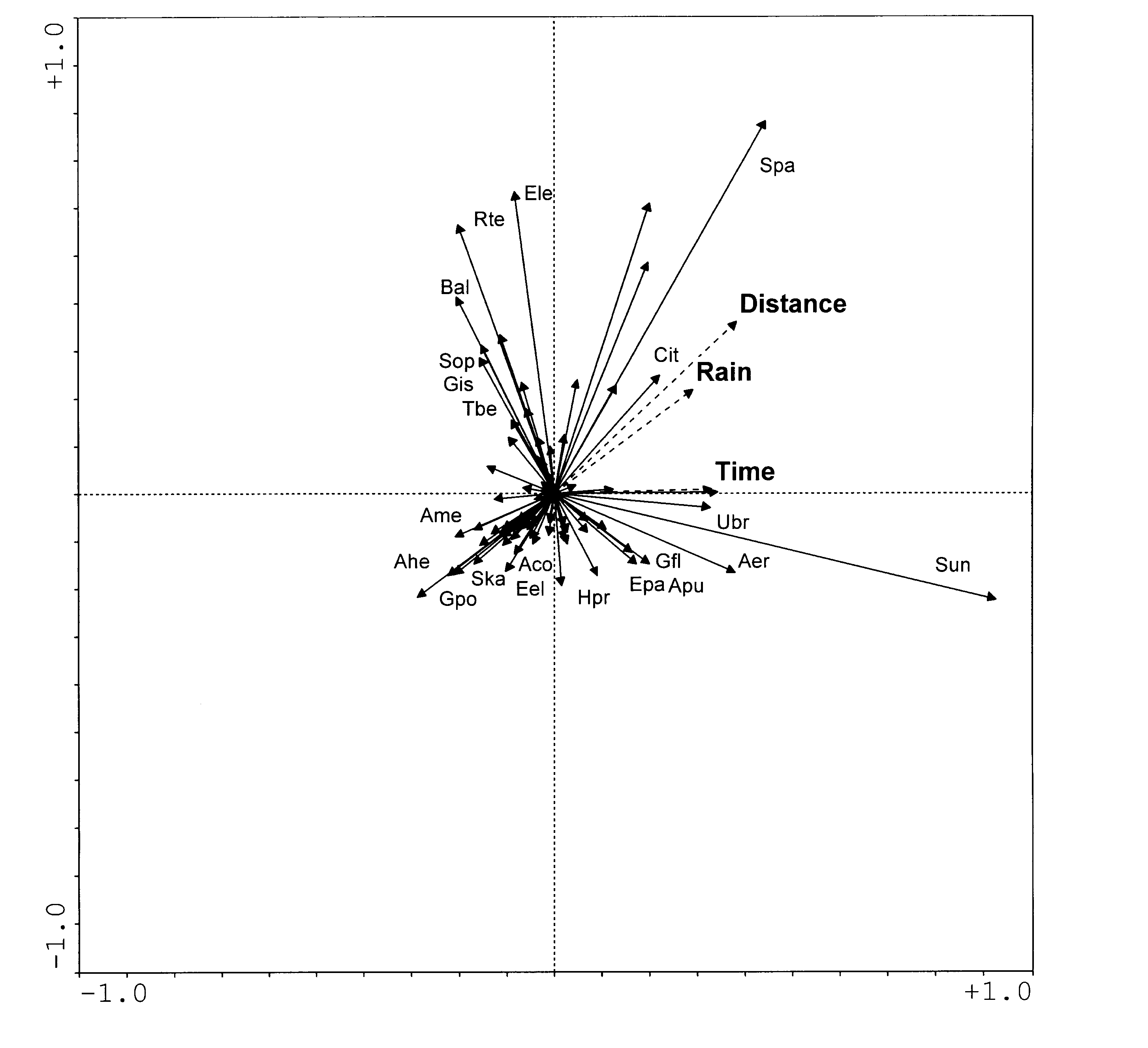
Life form data
Of the Raunkiaer life forms, hemicryptofytes (including most perennial grasses) had a strong, positive relationship to distance, and therophytes (annuals), phanerophytes (including trees and shrubs), geophytes and chamaephytes (including dwarf shrubs) had a weak, negative relationship to distance.
These life forms are based on how plants survive the non-growing season (winter or dry period) and are not directly related to herbivory. Still, it is clear that the hemicryptophytes, producing almost all their above-ground biomass anew each year, are palatable, and may lose a large proportion of their biomass to herbivores, and hence are not common where grazing pressure is high. The other life forms escape herbivory in one way or another, chamaephytes and phanerophytes by having a large proportion of their biomass in not so easily-eaten woody stems and branches, geophytes by storing resources underground, and therophytes by surviving only as seed.
Figure 2. A plot of the first two axes of a PCA showing selected Raunkiaer's life forms and environmental variables.
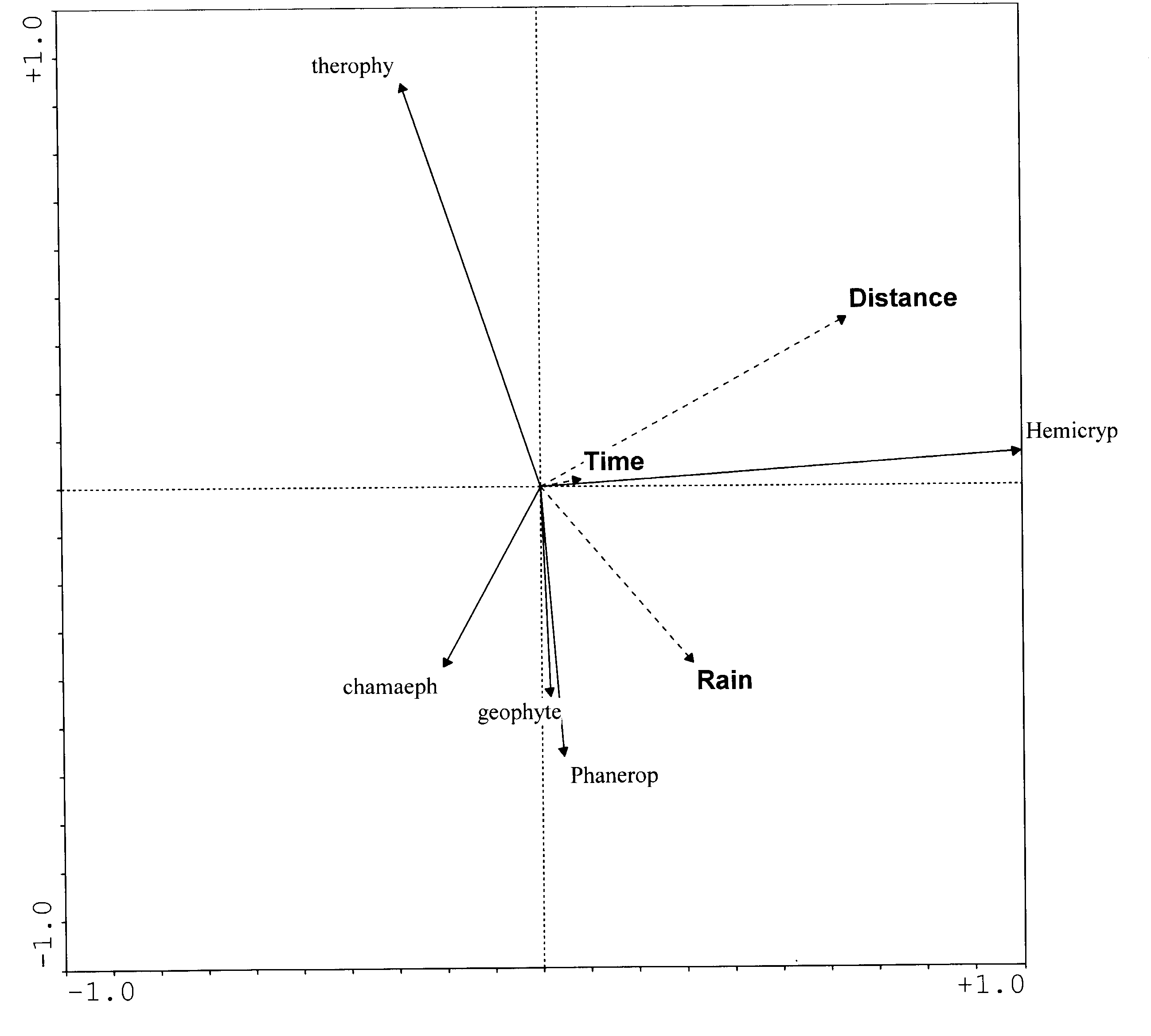
Plant functional traits
Of the functional traits tentatively used in this study, occurrence of perennial tufted grasses, perennial stoloniferous grasses and evergreen trees were positively correlated with distance, while dwarf shrubs, annual tufted grasses, annual forbs, thorny trees and deciduous trees were negatively correlated. The pattern and suggested explanation is similar to that above. These traits are, however, selected in order to be meaningful for the grazing animal.
Figure 3. A plot of the first two axes of a PCA showing herbivory-related plant traits and environmental variables. Acronyms are explained in Table 1.

Table 1. Herbivory related plant functional traits and acronyms used in Figure 3
Deciduous tree/shrubtr
Evergreen tree/shrub
Tree/shrub with thorns/spines/hooks
Tree/shrub without thorns/spines/hooks
Dwarf shrub
Perennial, tufted grass
Perennial stoloniferous grass
Annual tufted grass
Annual stoloniferous grass
Perennial upright forb
Perennial creeping forb
Annual upright forb
Annual creeping forbdecid
tr evergr
tr thorn
tr non-t
dw shrub
gr p tuf
gr p sto
gr a tuf
gr a sto
fo p tuf
fo p cre
fo a tuf
fo a cre3. Conclusion
The preliminary results suggest that distance from the villages (i.e., mainly grazing pressure) is the most important of the recorded environmental variables, and time the least important. This indicates that intensity of herbivory is important in shaping the vegetation, both in terms of species composition and in distribution of life forms and functional traits. The low importance of time suggests that there is no ongoing directed change (i.e., succession) in the vegetation, although there is considerable non-directed dynamics.
This supports the first of the three initially-stated hypotheses, suggesting that, when heavy livestock grazing is introduced to an area, or the grazing regime changes, the vegetation undergoes a directed change, or succession, meaning that species composition changes (Skarpe, in press). However, when species that suffer from the direct or, more commonly, indirect effects of the new herbivory regime have decreased or disappeared and, in most cases, others have taken their place, the directed change ceases but the non-directed dynamics remain.
4. References
Bergström R. 1992. Browse characteristics and impact of browsing on trees and shrubs in African savannas. Journal of Vegetation Science 3, 315-324.
Brundin J, Karlsson, P. 1999. Browse and browsers in south-western Kalahari. Swedish University of Agricultural Sciences. MFS Report 73.
Ellis JE, Swift DM. 1988. Stability of African pastoral ecosystems: alternative paradigms and implications for development. Journal of Range Management 41, 450-459.
Jongman RHG, ter Braak CJF, van Tongeren OFR. 1987. Data analysis in community and landscape ecology. Pudoc, Wageningen, The Netherlands.
Milchunas DG, Lauenroth WK. 1993. Quantitative effects of grazing on vegetation and soils over a global range of environments. Ecological Monographs 63, 327-366.
Moleele N. 1999. Bush encroachment and the role of browse in cattle production. The Department of Physical Geography, Stockholm University, Sweden. Dissertation No. 13.
Raunkiaer C. 1937. Plant life forms. Oxford:Clarendon.
Skarpe C. 1986. Plant community structure in relation to grazing and environmental changes along a north-south transect in the western Kalahari. Vegetatio 68, 3-18.
Skarpe C. 1992. Dynamics of savanna ecosystems. Journal of Vegetation Science 3, 293-300.
Skarpe C. Effects of large herbivores on competition and succession in natural savanna rangelands. In: Tow PG, Lazenby A. eds. Competition and succession in pastures. Wallingford, UK: CAB International. (in press)
Skarpe C, Bergström R. 1986. Nutrient content and digestibility of forage plants in relation to plant phenology and rainfall in the Kalahari, Botswana. Journal of Arid Environments 11, 147-164.
Ter Braak CJF, Smilauer P. 1998. Canoco 4. Centre for Biometry, Wageningen, The Netherlands.
Dr Christina Skarpe
PYRENEAN INSTITUTE OF ECOLOGY
As stated in the First Annual Report, the plans of the Spanish team were changed due to funding cuts and the political unrest in Lesotho. The only remaining task was to provide some ecological background to the work in that country. Nevertheless, efforts have continued in the climatic and hydrologic fields as well, in spite of the unforeseen setbacks. The tasks carried out during this year are grouped into four fields: data acquisition, mapping, modelling and ecology.
Work Package 2. Biophysical data collection and analysis
Task g. Basic climatic data
Data acquisition is related to the initial task 2g, and has been scheduled to proceed by means of two kinds of devices during this year and next. The first kind includes small portable devices (Hobo H8 Pro Series) to be buried or hidden at the observation sites. Four of these devices have been sent to the Lesotho mountains to take measurements of temperature and relative humidity at the selected sites. These sites are within and outside the RMA zone, and at high and moderate altitude, all in the Maloti Mountains. The first data will be available in the next few months. A fifth recorder is prepared to supplement the others in case of failure. Part of the job done was to test the devices in Spanish mountains, before sending them. Figure 1 shows the results of testing such a device in the Pyrenees, at 2300 m.a.s.l., during one year prior to October 98.
Fig. 1. Test of the automatic recording devices. Mean daily temperature of the soil in the testing site (Spain), during the years 1997-1998
The second kind of device is a complete meteorological station designed to measure and record climatic data of different types: temperature, humidity, snow depth, wind, sun radiation, features of water, etc. The list of variables is included in the First Annual Report; not all of these were actually gathered (19 of the 26 originally planned) as many others can be obtained indirectly from these. Finally the recorded variables were: air temperature, ultraviolet, infrared and visible radiation, wind speed and direction, water flow in the nearby Bokong River, turbidity, pH and conductivity of water, all these every minute; amount of rainfall every half an hour, depth of snow layer every day; indirect, daily, weekly and monthly records can be obtained from the precedent, such as mean, maxima and minima air temperatures, rainfall, snowfall, fastest gust of wind, sunshine hours, evaporation, and so on. This station was built and paid for by the Spanish team, and in the first months of this year was sent to Lesotho. Members of the Spanish and Lesotho teams carried the station to a suitable place in the upper Bokong watershed, Maloti Mountains, where the device was erected and commissioned. Programming the data measurement was challenging but, by April 1999, the first reliable data were recorded. Then, at the end of May, the meteorological station was vandalised. The solar panels were taken out and most of the recording devices destroyed. The Lesotho team devoted a significant part of their time to the care and maintenance of the station but, despite their considerable efforts, this unfortunate incident occurred. To assess the damage and recover the station is time-consuming, which is understandable given the remote location of the station. Another trip to Lesotho by the Spanish team is scheduled for mid-October for the purpose of dismantling and sending back the station to Spain. Therefore, this particular approach to climatic data acquisition must unfortunately be abandoned. We have only a few incomplete records, corresponding to the short period prior to the destruction of the station. Some of these records are illustrated below.

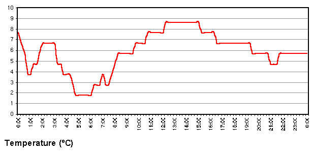
Fig 2: Some graphs of the few records produced by the meteorological station in Lesotho before its destruction by vandals. These are daily records of visible radiation, air temperature and relative humidity.
Task 2b. Survey of soil fertility and erodibility
Task 2c. Ecological analysis
Mapping of ecological features in Lesotho and in the study areas corresponds to the tasks 2b and 2c. We began by preparing general climatic maps for the whole country at scale 1:300000, a task which can also be included in Task 2g. Six of these were ready at the beginning of the year, while another has been added afterwards and two more are in preparation. These map the mean, maximum and minimum temperatures, the winter, summer and annual temperature ranges, and the rainfall as well as the general slope and the aspect. The maps in preparation are those of frost probability (number of days with probable frost) and solar radiation. A map of thunderstorm probabilities is also envisaged. These maps have been shown and discussed in the project meetings and elsewhere. Maps of aspects and slopes stem out directly from the DMT. Temperature and related maps rely on the equations of adiabatic lapse rate for different aspects in Lesotho. Precipitation maps usually rely also on the relationship between altitude and rainfall but, for Lesotho, this relationship holds only very weakly, as we have shown in a preliminary study. Therefore the precipitation map has been built after several contributions: first, the mentioned relationship; second, the general NE-SW aridity gradient well known for Lesotho; third, a smoothed interpolation map between the mean rainfall values given by all the meteorological stations of the country; and fourth, a filtering function taking into account the screen and barrier effect of the main mountain ranges of the country in face of the prevailing winds. Figure 3 shows the precipitation map. The scale here is not the 1:300000 scale of the original map, as it has been reduced to fit.

Fig. 3: One of the climatic maps of the country produced as a basis for the ecological studies. Numerical scale is not true, but graphical one is.
Another mapping task, covering only the RMA study area and the non-RMA control area, at scale 1:50000 is being prepared. This has also been a challenge. Digitalizing the maps and obtaining the digital model of terrain has been a huge task, slow and prone to errors. This was planned to be finished by March, 1999, but finally has been finished quite recently (Figure 4). Now the first detailed climatic maps can be prepared in the coming months.
Fig. 4. A digital model of the non-RMA control area in the Maloti Mts, Lesotho. The DMT is the basic tool used to prepare all the climatic and environmental maps planned. This area is the upper part of the Malibamatso valley, near the Oxbow Lodge, looked at from the south-west.
The mapping approach is a short cut in the face of the difficulty of obtaining enough data for the elaboration of classical, dynamic models (Figure 5). There is a plethora of such models to simulate the behaviour of organic systems, from organisms to an entire biome or even the whole biosphere, but most of these models are not spatially distributed. The number of spatially-distributed models available is, however, still very high. A great majority of these are clumsy, require a lot of data, and many years to be built and tested. Simple map models, built by superposition of many individual GIS layers, are not so difficult to build and much easier to understand. We are trying this approach after several attempts at building classical models of Lesotho mountain rangelands, an endeavour which is being carried out by other teams of the project.
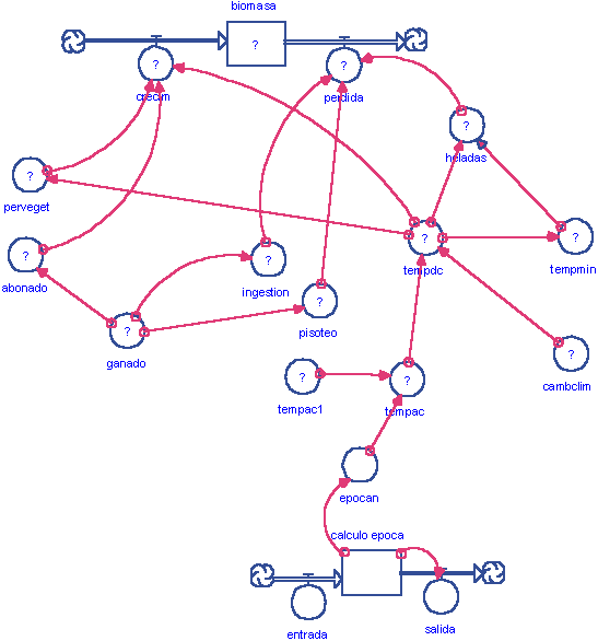
Fig. 5. The first steps in the development of a model of the changes of biomass in the mountain pastures of Lesotho. This is only a crude sketch made with the package STELLA 5.0. Only a few of the involved stocks and rates are shown.
Ecology has been the least attended item in the project. Of course, the Spanish team should work here in close connection with Lesotho or South African specialists. Several of these have joined the project only to change their job in a few months. The drawbacks experienced by the Lesotho team (military unrest, destruction of observation devices) did not help to arrange the matter. The Spanish team contacted some people involved in Lesotho development projects, some of them dealing with biodiversity issues, got some material about Lesotho grasslands and mountain flora, and tried to have a local or South African specialist involved. During the next planned trip to Lesotho, a new ecologist will be contacted, and surely this field should start to give results too (see report by National University of Lesotho).
Mention should be made of the efforts to make the results known. Many of these efforts have already been explained in the half-yearly report of March 1999. Among these we include travel to Chile in October 1998 to obtain help in the modelling effort, attendance at the Barcelona LUCC meeting in November 1998, attendance at the 2nd Project Workshop held in Paulshoek, Namaqualand, South Africa in March 1999 (our contribution to the project is included in the proceedings of this workshop), and scheduled attendance at the GCTE Food and Forestry: Global Change and Global Challenges Conference in Reading, U.K., in September 1999, an attendance which was unfortunately cancelled due to the lack of data resulting from the destruction of the meteorological station. Moreover some results related to the project have been presented outside it, as not directly obtained in the framework of it, for instance, data on biodiversity studies in other, non-African, mountain ranges.
Dr Juan Pablo Martinez Rica
UNIVERSITY OF BOTSWANA
1. Introduction
The aims of this second annual report are to describe the project activities undertaken by the UB team during the last year (nature, opportunities and constraints), and to highlight some major research results.
In March 1999, the 2nd Project Workshop was held in Namaqualand, South Africa, and was attended by two members of the Botswana team.
2. Activities and Progress
2.1 Work package 1. Project initiation and community participation
Task c. Community participation and training
2.1.1. Information feedback
The team is in regular contact with government officials and traditional authorities in the area. This is done during regular visits to the area and during a visit to the capital of the Kgalagadi district (Tshabong). Feedback meetings for communities were organised in Tshane and in Ngwatle where, in 1998, general surveys were held and where, in early 1999, PRA exercises were conducted. The feedback meetings were much appreciated by the villagers as most research projects do not communicate their findings back to them.2.1.2. Initiation of Rangeland Resource Use Monitoring System (RRUMS)
It was decided, with assistance from Dr Ian Robinson, CAZS, to start a rangeland resource use monitoring system (RRUMS) with households in Tshane and Ngwatle. Households and the relevant extension workers were part of this decision, and were subsequently trained. Both groups contributed in the design of the recording sheets.2.2 Work package 2: Biophysical data collection and analysis
2.2.1 Task a. Basic survey of water sources and hydrology
Eighty-eight water samples were collected from wells during the dry season (1998) and the wet season (1999). All the wells were geo-referenced using a GPS. The samples were analysed for: CO3, C1, SO4, NO3, F, Br, K, Na, Ca, pH and TDS. The results from the dry season indicate that water sources are very saline. The accepted TDS figures for potable water by WHO standards is 45 ppm but in this study samples have values of 1000 ppm. Chloride levels are 200-210 ppm (below the WHO standard of 250 ppm). Nitrate levels for most samples range from 170 to 200 ppm, and exceed the drinking standards.The main problem has been lack of lab capacity. Analytical laboratory facilities are not available at UB. The 1998 water samples were analysed at the Department of Water Affairs (DWA) but they were unwilling to analyse the 1999 samples. Preparations will be made before sample collection to ensure that water samples are analysed immediately afterwards.
While the emphasis has been on water quality, borehole yield data have been collected from council boreholes for 5 consecutive years. No clear trend in yields was observed. However, salinity is rapidly becoming a problem in the water supply of settlements. It is likely that water extraction is exceeding the recharge causing saline intrusion into the freshwater aquifers. This may become the most critical issue regarding sustainability.
2.2.2 Task b. Survey of soil fertility and erodibility
The work has focused on the analysis of soil samples taken during July 1998 (dry season) and March 1999 (wet season) in order to assess soil quality; pH, EC, Na, K, Ca, Mg, P, CEC, organic matter content and particle size were analysed. The soils generally have a low nutritional status as evidenced by very low figures, 0.00-0.007 ppm for available P. The pH of the soils is around 6-7, a range suitable for most crops like sorghum, maize and beans. EC values are locally high. Soils in the study area have mostly coarse and fine sandy texture (90% content) with low water-holding capacity.The results confirm that the soils of the Kalahari are very poor nutritionally and structurally with poor water-holding capacity in line with expectations. Until the wet season samples have been analysed, no comparison can be made between the dry and wet season. The large number of samples and the premature resignation of the Project Research Fellow have caused a backlog. A number of tests still have to be done especially on Dr Skarpe's soil samples (only soil organic matter, EC and soil pH has been undertaken on her samples). Therefore, priority is given to sample analysis rather than collecting more samples. The sample results will be superimposed on existing soil maps in order to provide a more detailed soil picture to address the issues of soil degradation and erodibility.
2.2.3 Task c. Ecological analysis
Fieldwork is being conducted along two transects adjacent to the Tshane-Tsabong road and the Hukuntsi-Ngwatle road. The origin of each transect lies in a village (Tshane or Hukuntsi), where pans and wells provide the major source of water for livestock and where the human population density is relatively high. Sampling was done at three sites along these transects at 4 km (heavily-grazed zone), 18 km (moderately-grazed zone) and 40 km (wildlife management area) distance from the villages. The transects represent a gradual decline in resource use intensity and in the dominant type of land use (see also NINA report, this volume). The data sets are available for two dry seasons (winter 1998 & 1999) and one wet season (summer 1998). The last sampling will be done during the next wet season (summer 1999). The data collected are used to determine the standing crop of common herbaceous plants with distance from the water source (Tshane and Hukuntsi pans); to assess the impact of grazing on species diversity, particularly palatable grasses; and to assess the diversity, density and canopy cover of woody plants along the transects. The data are also correlated with findings from the browse studies conducted by NINA.Thus far, the 1998 dry season data for the Tshane-Tsabong transect have been analysed. As more data are analysed, we will compare changes along the two transects and between seasons.
The vegetation work is done in collaboration with NINA, and is reported in detail in that report. The NINA work focuses on browsing aspects and wildlife along the transects (see NINA report).
Land-use mapping
Work has commenced on the mapping of land-use changes in the study area. The overall goal of this component is to understand the pattern of change in land use and the impact of such changes on vegetation species composition, cover and density. This will in part help to understand the patterns exhibited by wildlife species dynamics in the area. The specific purpose of this study is to investigate how changes in land use have affected the woody vegetation composition, aerial extent, cover and density in the Matsheng area. Three sets of panchromatic photographs (black and white: 1971, 1976 and 1986) were available for the interpretation along the transects. Changes in grassland areas, woody thorny vegetation (bush encroachment), other woody vegetation, bare soil, pan, boreholes/cattleposts/huts, active fields and abandoned fields have been mapped.The results will be linked to the 1998 and 1999 vegetation samples. The latter are important for ground-truthing. Soils data collected at the sampling sites will also be linked to the photo-interpretation work.
A comparison is being made for 1971-1986 for one transect and for 1976-1986 for the other transect. Along both transects, aerial photo-interpretation and ground checks provide detailed insights in land use and vegetation changes at increasing distance from villages. Moreover, it allows the comparison of different land use zones, i.e., crop areas, grazing areas and wildlife management areas. Ground checks are difficult and time-consuming because of the changes that have taken place since 1986. The final ground-truthing is planned for October 1999.
2.2.4 Basic climatic data
This is an ongoing activity that expands the climatic time series provided in Task 0.2.3 Work package 3. Socio-economic data collection and analysis
Tasks a-e
2.3.1 Participatory rural appraisal
PRA exercises were conducted in Tshane and Ngwatle to supplement previous surveys. The following instruments were used: sketch maps, time and trend lines, seasonal calendar, livelihood mapping and problem analysis. The results have been analysed, and, after discussions in the villages, have been incorporated in a project report. Some of the major results are summarised below:
A downward trend exists for crop harvest, veldproducts and wildlife, particularly in Tshane. In Ngwatle, the downward trend has been slower; veldproducts are not really scarce but are rarely used for food anymore (because of food rations provided by an NGO); they continue to be used as medicines.
Women are more in control of the immediate village environment; men "control" the more distant areas (livestock and wildlife).
Poverty is most severe in Ngwatle (almost universal) and among women and Balala in Tshane. Poverty implies poor housing, poor health, many children, no livestock or employment and no relatives who can assist. On the other hand, wealth is associated with large herds, vehicles, formal employment or business ownership of assets such as boreholes and farms.
The gender labour distribution differs somewhat between Tshane and Ngwatle. Divisions are more distinct in Tshane. Typical male activities are livestock-rearing and, in particular, hunting and formal business. Typical female activities are gathering and informal business. Interestingly, opinion differs on arable farming: men believe that they are mostly involved while women believe that they are more active. In Ngwatle, men and women equally participate in craft and gathering. Goats are the domain of men, while back gardens are mostly controlled by women.
Contrary to the survey findings, arable farming and livestock appear as the two most important forms of livelihood in Tshane. In Ngwatle, crafts, charity and government assistance are most important.
The four most important community problems in Tshane are low harvests, lack of grazing land, water scarcity and poverty; in Ngwatle, lack of services is an added problem while lack of grazing and low harvests were not ranked high.
2.3.2 Analysis of 1998 surveys
Data from the 1998 general survey and the budget and resource allocation survey in Tshane and Ngwatle have been analysed and some major findings are summarised below:
Rangelands do not contribute significantly to rural livelihoods. Remittances, government support and formal employment are more important (Figures 1 and 2).
There is a marked difference between the frequency of participation in agriculture, gathering and hunting, and the importance of such activities for income generation and livelihoods in the two villages.
Rangelands are perceived as being more degraded now than in the recent past (85% and 60% of the respondents in Tshane and Ngwatle respectively). This perception is more widely held in the villages than among remote area settlements, possibly because of the higher population and livestock density.
The most commonly perceived cause of diminishing rangeland productivity in relation to traditional uses is drought and to a lesser extent predation by wildlife on cattle, excessive hunting of wildlife, and fires which affect natural products (Figures 3-5).
Most households do not believe that their livestock contributes to degradation (e.g., 65% of the households in Tshane). In other words, degradation is beyond the control of the population. However, climatic time series do not support this view. This "externalisation tendency" renders management interventions more difficult.
Gender, livestock ownership and ethnicity emerge as the major, interdependent, socio-economic determinants of activity patterns. Some examples are:
Cattle ownership is significantly skewed against female-headed households in Tshane (c 2 = 9.9, p<0.001). Sixty-nine percent of households without cattle were female-headed, and a majority (67%) of female-headed households with cattle owned less than 11 head.
Similarly, women headed 64% of families that did not have goats in Tshane. In Ngwatle, 82% of female-headed households had no goats at all.
Female-headed households constitute the largest proportion (65%) of families without any source of cash income in Tshane. Similarly, the majority of families depending on remittances and government support for cash incomes were female-headed (75% and 65% respectively). This observation applies to the pattern of in-kind income sources as well (60% and 64% respectively).
Rangelands are simultaneously used for multiple purposes, which produce a variety of products. The dependency of each household on each activity is strongly related to its welfare. Table 1 summarises the main uses and products. Rangelands are important for various facets of livelihoods, and maintenance of biodiversity would strengthen the resilience of the rural population (e.g., in the event that government would have to reduce or even withdraw its current support). In other words, bush encroachment could have an adverse impact on livelihood security.
Ms. Kgabung successfully completed her Masters dissertation on the impact of livestock encroachment on wildlife and veldproduct resources and their use.
2.3.3 New surveys
Following the analysis of the 1998 general survey and budget and resource allocation survey, it was felt that a large-scale repetition of the general survey was not necessary. Rather, three areas were identified for in-depth follow-up work:
The evaluation of the performance of fenced ranches in the area. Fenced ranches are a possible intervention to improve rangeland management, and are currently propagated by the Ministry of Agriculture. Five ranchers (out of 8) were interviewed using a questionnaire. In addition, visual observation was used to assess the level of ranch development and the rangeland conditions inside and outside the ranch. At a later stage, our ecologists will make a formal ecological assessment.
Identification of markets of rangeland products and flows of income and financial support. This topic required an investigative approach based on discussions with government officials, local shops and markets, and literature analysis. This is an ongoing exercise, which extends into year 3 of the project.
A detailed survey of the impact of wildlife disappearance on livelihoods in villages. It is a sequel to Kgabung�s work on the impact of livestock expansion. The survey was done in Lokgwabe (110 households). Because of built-in overlap with the general '98 survey, the study offers an opportunity to gain some insight into possible changes that may have occurred between 1998 and 1999. As livestock encroachment and wildlife disappearance are the dominant land use changes, the impact of change is now covered by the study.
Figure 1: Principal cash income sources in Tshane, July 1998 (% citing sources)
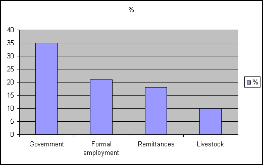
Figure 2: Principal cash income sources in Ngwatle, July 1998 (% citing sources)
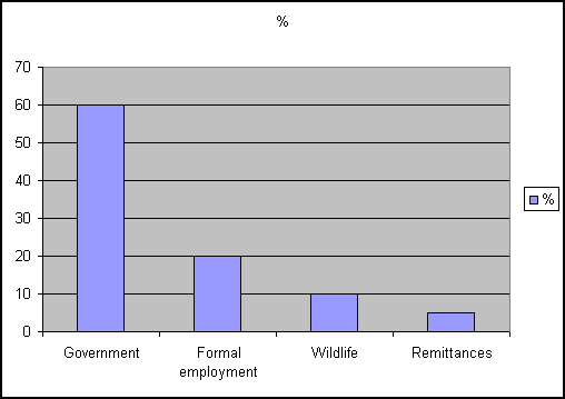
Figure 3: Perceived constraints to cattle production (Tshane) (% responding) (n=48)

Figure 4: Perceived causes of wildlife scarcity (% citations) (Tshane and Ngwatle)
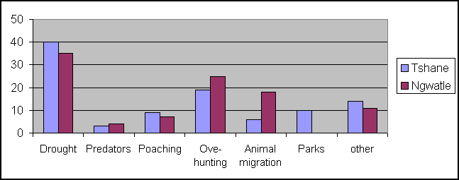
(citations not mutually exclusive: cannot add up to 100%)Figure 5: Perceived causes of natural (veld) product scarcity (% citations; not mutually exclusive) Tshane and Ngwatle
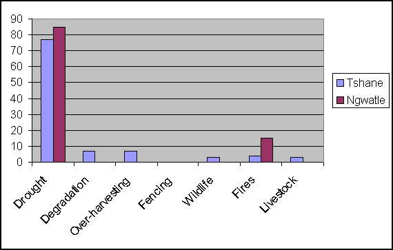
Table 1: Summary of major rangeland products by activity
GATHERING
WILDLIFE
CATTLE
SMALLSTOCK
USE
Food
Wild fruits, wild potatoes and vegetables
Meat
Milk and meat
Milk and meat
Construction material
Poles, rafters, thatch, fences
Utensils
Spoons, cups, mortars
Skins, belts
Skins, belts
Skins, belts
Personal ornaments
Beads, headbands, necklaces, bracelets, beads
Medicines
Grapple plant
Fuel
Wood
Cash
Rare; few veld-products are sold
Sales, mostly of crafts
Sales
Sales
Others
Use of oxen for draughtpower is not common
2.3.4 Rangeland Resource Use Monitoring System (RRUMS)
The RRUM system became operational in June. It covers the main livelihood activities, i.e., crop production, livestock, wildlife and gathering. Seven families participate in Ngwatle, 14 in Tshane. Families have been selected on several grounds: activity patterns, interest of the family and advice of extension workers. Families were equipped with stationery, and sets of scales were located at convenient places in the villages. Families are visited during the last week of each month. During these visits, problems are discussed and recording is checked and modified when necessary. Recording in June was relatively poor but it improved in July. If progress continues, reliable RRUMS data for an entire year will be available. This will allow the project to gain an insight into the seasonality of inputs and outputs. Some of the problems encountered include:
- Tendency to be qualitative. This requires detailed probing upon visits.
- A herbalist/traditional doctor, who has been away for two months, heads one of the families.
- Not all families measure the use of resources such as firewood.
- Not all families have understood that they must record weekly and that recordings should be restricted to that week�s activity.
The merging problems are resolved during the visit by project staff.
The resignation of the full-time project researcher in June ("in search of greener pastures") has been the main problem. Temporary measures have been put in place, however, to ensure continuity until a successor has been appointed. The RRUMS has been set up in close collaboration with CAZS, University of Wales.
2.4. Work package 4: Resource management and policy analysis
2.4.1 Task 4a. Economic valuation of rangelands
A Masters student works on this project for her dissertation. She is currently working on a methodology paper and the literature review. Fieldwork is planned for November-December while the dissertation should be ready by August 2000. The study includes desk and field research, probably in Ngwatle. It will generate insight into the use values of grazing and wildlife areas and in the willingness to pay for extra grazing land or alternatively the willingness to accept compensation for the loss of wildlife area.2.4.2 Task 4b. Policy evaluation
Interviews at the district level have been completed. Further fieldwork was done in the Matsheng area and in the district capital, Tshabong. Further interviews will be conducted in Gaborone. Although people are generally co-operative, it proved difficult to get feedback from some officers.The impact of policies on people�s livelihood is large. Three types of policies exist: welfare programmes, production support programmes and public services programmes. Some of the findings are:
Settlements such as Ngwatle primarily depend on welfare programmes. Families have become dependent on such support and, unfortunately, they know little about, let alone use, production support programmes. This restricts their future chances to meet their own needs. (It might be noted that Ngwatle has no permanent water; water is brought in by bowser.)
Villages benefit more from agricultural programmes, in particular borehole drilling, livestock subsidies, etc.
The relative benefits of most government programmes is inversely related to the distance to the settlement from which the programme is administered (Tshabong or Hukuntsi).
Production-support programmes apply nationwide and as a result some components are less relevant for the study area (e.g., draughtpower).
Programmes that are meant to diversify the local economy away from agriculture, remain predominantly agricultural (e.g., FAP funds large numbers of small stock).
Male-headed households are the primary beneficiaries from cattle programmes, female-headed households from smallstock support through FAP. The latter is due to the fact that women receive higher subsidies under FAP. Extension staff believe that some women are "fronting" for their partner, hence not really contributing to asset accumulation by women.
The Ministry of Agriculture is pushing ahead with fencing of communal grazing areas without due consideration for the fact that earlier ranches appear a failure. Initially, fencing was presented to the area as a necessity to meet the EU requirement of traceability of beef sold to the EU. It is now recognised that fencing is not an EU requirement. However, fencing plans have been set in motion.
2.4.3 Task 4c. Government Intervention
Beef pricing and marketing study
This study involves a thorough analysis of the agricultural statistics and fieldwork in the study area. Data collection has been completed. Collected data include off-take rates, prices and market outlets. Data interpretation is ongoing.
2.5 Work package 5. Integration and synthesis
Integration has been at the core of the Botswana activities from the outset. Studies have been designed to provide information on the components and relationships of the figures contained in the project proposal. In addition, the studies have focused on the identification of other components and interactions of importance to the field site. For example, water and wildlife are important to understand rangeland and livelihood dynamics.
3. Resources
3.1 Manpower and training
The research team has further expanded during the year (at present 9 members at UB; one member at the Ministry of Agriculture). Consequently, the project contributes to local research capacity building at UB, and encourages collaboration among UB departments (Env. Science, Economics, Biology and History). Through student involvement, valuable training opportunities are offered to local students.
Upon his return from study leave, Dr Moleele joined the team and got involved in the ecological and land use components. His dissertation dealt with bush encroachment in rangelands in Kgatleng District. Moreover, Ms Bolaane has joined the team to carry out the historical study.
Ms Magole left for PhD studies in September 1999 (University of East Anglia). Her topic (Evaluation of traditional and contemporary institutions of land resource management in the Kgalagadi north sub-district) is closely related to the project, and she is expected to do her fieldwork June-September 2000 under the auspices of the project.
Training offered:
- Soil sample analysis training of 4 undergraduate students
- Vegetation analysis training of two undergraduate students
- Research project for an undergraduate student (two years ongoing)
- Masters dissertation training for one student (completed in 1999)
- Two Masters students started their dissertation work within the project in July 1999.
- Survey training of two undergraduate students.
Visiting scientists:
- Coordinators' visit by Dr Tony Chamberlain, CAZS
- Dr Robinson, CAZS, provided valuable inputs in RRUMS
- Dr Skarpe, NINA, assisted with ecological work (browsing and wildlife)
- An American PhD candidate held discussions to find out whether he could do his PhD related to the project (policy evaluation)
- Two NINA students carried out ecological fieldwork
- Coordinators' visit by Prof Gareth Wyn Jones & Dr Einir Young, CAZS
- Coordinators' visit by Dr Einir Young, CAZS.
3.2 Finances
Because of the small size of the EU second disbursement and the claw-back of part of the initial advance, some cash flow problems have been experienced. However, commitments have been made through the good offices of the University, and disbursements are expected to run close to schedule this year.
4. Publications and Papers
*Arntzen JW. 1998. Rangelands and subsistence livelihoods in southern Africa. LUCC Newsletter, 4.
*Chanda R. 1999. The Role of Attitudes and Behaviour in Environmental Management: Theory and Illustrations from Southern Africa. Poster presentation at the international IHDP Global Change Conference, Japan, 24-26 June 1999.
*Arntzen J, Chanda R, Fidzani N H and Magole L. 1999. Subsistence Livelihoods and Rangeland Dynamics in the Matsheng Area, Kgalagadi North, Botswana. 18 pages. In: Ringrose S, Chanda R. eds. Towards Sustainable Management in the Kalahari Region, 189-209, UB-DRD Conference Proceedings.
Moganane BG, Maembolwa J, Totolo O, Molapong KF. 1999. Changes in soil characteristics along the Kalahari transect in Botswana. In: Ringrose, Chanda R. eds. ibid., 66-73.
Setshogo M, Totolo O, Tacheba G, Skarpe C. 1999. The Biophysical Dimensions of Subsistence Rangelands in the Matsheng Area. In: Ringrose, Chanda R. eds. ibid, 177-187.
*Chanda R, Magole L. 1999. Traditional Questionnaire Survey versus Participatory Rural Appraisal: Complementary or Supplementary? A Comparative Assessment using a Case Study from Botswana. In: Rwomire A. Social science research in Africa. Gaborone: Department of Environmental Science, University of Botswana.
Magole L. 1999. Report of the PRA Workshops in Tshane and Ngwatle. 23 pp.
Chanda R. 1999. Project presentation at seminar series for the School of International Training (for visiting US students), Gaborone.
Chanda R, Moleele N. 1999. Project presentation at the international SAFARI 2000 Conference, July 1999, Gaborone.
Kgabung B. 1999. The impact of livestock encroachment on wildlife and veldproducts availability and utilisation. MSc dissertation, Department of Environmental Science, University of Botswana.
Project mentioned in round-table discussion about water scarcity (Radio Botswana).
*Note: Three copies each of publications marked with an asterisk are being sent to the EC with this report. Copies of student dissertations have not been supplied to the EC with this report on the instructions of Mr Dirk Pottier, DG XII.
Dr Jaap Arntzen
DRAFT WORK PLAN FOR 1999/00
Work package 1: Project initiation and community participation
|
Activity |
Project staff |
External inputs |
Timing |
|
Feedback of results to extension workers and communities |
All |
Continuous |
|
|
Monthly monitoring and feedback visits for RRUMS |
Research fellow + Fidzani |
CAZS, Robinson |
Monthly |
|
Feedback meetings with villages about project results |
All |
July |
Work package 2: Biophysical data collection and analysis
|
Activity |
Project staff |
External inputs |
Timing |
|
Reporting |
All |
NINA |
Continuous |
|
Soil sample analysis ; soil fertility and degradation/ erodibility |
Totolo + PRF |
Oct-Dec/99 |
|
|
Improved soils map |
Totolo + PRF |
??? |
|
|
Water sampling, and analysis |
Totolo |
Analysis in lab |
December-January |
|
Water point and water quality mapping |
Totolo + PRF |
||
|
Vegetation: 1 collection + sample analysis |
Setshogo, Tacheba, Moleele + PRF |
Dec 99 sample collection |
|
|
Ecological assessment of TGLP farms and neighbouring communal areas. |
Setshogo, Moleele, Tacheba + PRF |
December 99 |
|
|
Vegetation map |
Setshogo, Moleele, Tacheba |
January-June 2000 |
|
|
Identification of plant specimens, estimate of bio-mass productivity |
Setshogo, Tacheba + PRF |
NINA |
Species identification: Oct-Dec.; Bio-mass estimates January-June 2000 |
|
Land use change mapping and improved land-use map |
Moleele |
Field trip short break 99; map January-June 2000 |
Work package 3: Socio-economic data collection and analysis
|
Activity |
Project staff |
External inputs |
Timing |
|
Reporting |
All |
Continuous |
|
|
Possibility of a general survey (follow up of 1998). |
SRF |
June-July 2000 |
|
|
Completion of 1998 general and BRA survey analysis; |
Chanda, Fidzani, Arntzen |
October-November 99 |
|
|
Completion of the 1999 marketing and financial flows analysis (MAFFA) |
Arntzen + SRF |
December-January 2000 |
|
|
Completion of 1999 TGLP study |
Chanda +SRF |
December-January 2000 |
|
|
Study on the effects on wildlife depletion on rural livelihoods in villages (Student project) |
Mbututu |
October 99- May 2000 |
|
|
Historical analysis of global change, rangeland changes and changes in livelihoods |
Bolaane |
Archival work until October. Fieldwork October-December 99. Report before Ph.D departure |
|
|
Secondary literature analysis |
all social researchers |
Throughout 99 |
|
|
RRUMS by farmers in Tshane and Ngwatle |
SRF |
CAZS, Robinson |
Start June 99 for one year |
|
Economic valuation of rangelands (MSc dissertation) |
Amusa |
October 99- August 2000 |
Work package 4: Resource management and policy analysis
|
Activity |
Project staff |
External input |
Timing |
|
Policy assessment interviews in Gaborone |
Arntzen + SRF |
October-December 99 |
|
|
Policy analysis and reporting |
Arntzen + SRF |
January-March 2000 |
|
|
Study of beef pricing and off-take rates (scenario analysis); reporting |
Fidzani |
??? |
Work package 5: Integration and synthesis
|
Activity |
Project staff |
External input |
Timing |
|
Development of climatic time series for Matsheng |
Setshogo + PRF |
IPE-Spain ? |
Continuous |
|
Development of long-term trends in animal numbers |
Arntzen + SRF |
Continuous |
|
|
Identify and construct global change scenarios |
All |
ITE and CAZS |
January-March 2000 |
|
Simple GIS system for study area |
Sebego |
DWNP, BRIMP |
January-September 2000 |
|
Prepare findings for modelling |
Fidzani |
ITE |
?? |
|
Construction of a database |
Fidzani, SRF |
January-September 2000 |
Note:
1. More external inputs are welcome. We hope to link up with IPE for the climate data. Perhaps CAZS is interested in becoming involved in the policy evaluation. We further hope to have opportunities to involve staff from South Africa and Lesotho (and perhaps vice versa).
2. Involvement of students is subject to availability and their choice of subject. Mbututu (undergraduate) and Amusa (Masters) work on the project. The project is open to student work from other partners subject to capacity and suitability.
3. PRF = physical research fellow; SRF = social research fellow; RRUMS: rangeland resource monitoring system; BRA = budget and resource allocation survey.
